Southwest Climate Outlook - El Niño Tracker - April 2020
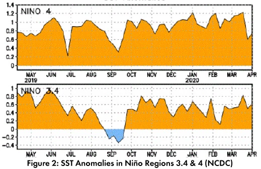
There are positive sea surface temperature (SST) anomalies across the equatorial Pacific (Figs. 1-2). Forecasts expect conditions will stay within the range of ENSO-neutral through at least summer 2020, with hints at a possible La Niña later in 2020.


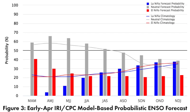
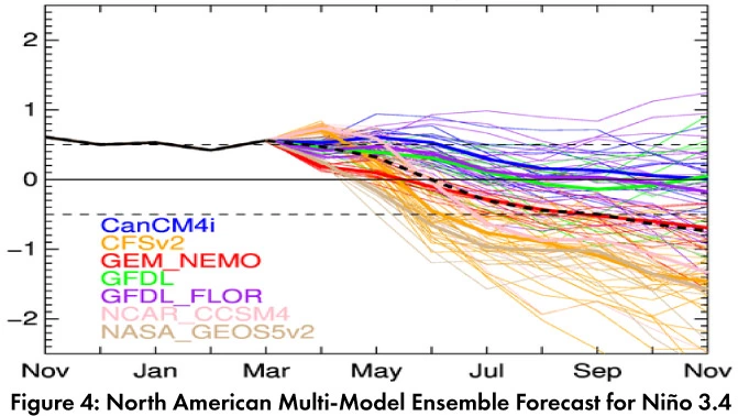
Forecast Roundup: On Apr 9, the NOAA Climate Prediction Center (CPC) issued its ENSO diagnostic discussion with an inactive alert status. The CPC called for a 60-percent chance of ENSOneutral through summer 2020 and remains the most likely outcome through fall 2020. On Apr 9, the International Research Institute (IRI) issued an ENSO Quick Look (Fig. 3), noting “SSTs…near the borderline of El Niño during early April,” but no corresponding atmospheric conditions. They highlight that most models remain warm through spring with cooling over summer and also call for ENSOneutral conditions through fall 2020. On Apr 10, the Japanese Meteorological Agency (JMA) maintained its call for a 60-percent chance of ENSO-neutral conditions to last until summer 2020. On Apr 14, the Australian Bureau of Meteorology maintained their ENSO outlook at an inactive status but did highlight that a few models were beginning to suggest the possibility of a La Niña. The Feb 2020 North American Multi-Model Ensemble (NMME) remains borderline El Niño but shows steady movement into ENSO-neutral territory through the summer, and approaching La Niña conditions later in 2020 (see dashed black line, Fig. 4).


Summary: SST anomalies hovered at the El Niño border for months. To be considered an El Niño event, the three-month SST average would need to stay above the El Niño threshold for five consecutive months, and the atmosphere would need to cooperate (i.e. ‘oceanicatmospheric coupling’), neither of which has happened. ENSOneutral conditions are forecast to last through summer and into fall, with recognition of the challenges associated with the spring predictability barrier (i.e., the difficulty of accurate forecasts made this time of year). In the Southwest, ENSO-neutral winters produce some of the wettest and driest winters (and everything in between). This winter has been particularly wet across parts of the Southwest, especially when averaged across longer timescales (such as seasonal or water-year; for details see pp 1-2 of this outlook, and the Mar 2020 SW Climate Outlook). The next few months are typically dry in much of the arid Southwest, so any precipitation will be welcome (but not necessarily expected). We look to the onset of the monsoon for the next period of regular precipitation activity.
Online Resources
- Figures 1 - Australian Bureau of Meteorology - bom.gov.au/climate/enso
- Figure 2 - NOAA - Climate Prediction Center - cpc.ncep.noaa.gov
- Figure 3 - International Research Institute for Climate and Society - iri.columbia.edu
- Figure 4 - NOAA - Climate Prediction Center - cpc.ncep.noaa.gov

