About - Monsoon:
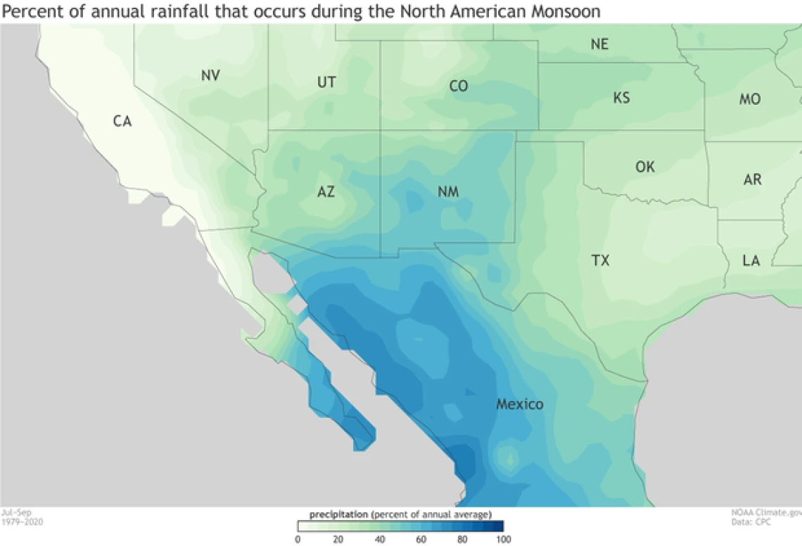
Across Arizona and New Mexico, the wettest single month of the year will likely be July or August; on average, these two months account for up to half the precipitation that falls in a year. Communities in the Southwest depend on the monsoon–to moderate hot summer temperatures, to relieve demands on water resources, and to drive vegetation productivity. Flooding and extreme precipitation events during the monsoon season also coincide with peaks in foodborne and waterborne illnesses as extreme precipitation can facilitate pathogen spread in the environment and infiltration into water supplies. Decreased water quality following flooding is particularly a concern for private well users.

Percent of total annual precipitation occurring during the monsoon season, July–September ( based on 1979–2020, data CPC Unified rain-gauge-based dataset). Figure by climate.gov.
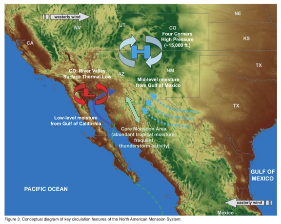
The monsoon high, or monsoon ridge, is a feature of the atmospheric circulation that plays a key role in determining how a given monsoon season plays out. It is characterized by an area of upper level high pressure–an anticyclone–driving clockwise flow of the atmosphere that builds and shifts north in the summer, ultimately covering much of the continental United States, usually some time after the summer solstice. When the center of the clockwise flow is far enough to the north, weak, easterly to southeasterly flow over the southern U.S. and Mexico allows air moistened by the Gulf of Mexico and the Gulf of California to move into the Southwest. The core of the North American Monsoon region lies to the south along the coasts of Mexico, and storm activity begins there earlier in the season and acts to push the moisture further and further north. Once the moisture has moved into the Southwest, the position of the center of the monsoon high determines where thunderstorms will occur, and whether they will organize and form stronger, longer-lasting systems. Near the center of the high, storms are often suppressed; farther away, conditions can be more favorable.
Monsoon onset is tracked by surface dewpoint and precipitable water. Both measures indicate the moisture content of the air. Once thresholds of dewpoints and precipitation water are met, thunderstorms can occur. While the beginning of the monsoon season is welcomed by humans and natural ecosystems, the increased humidity that accompanies higher dewpoints and monsoon rains also can contribute to health risks.

Conceptual diagram of key circulation features of the North American Monsoon System.
Locally, increased humidity in the summer months can make the extreme heat more unbearable resulting in a greater heat-related illnesses and deaths. Additionally, the combined warmer temperatures and increased humidity often mean greater survival and longer breeding seasons for mosquitoes increasing the risk of vector-borne disease transmission.
Monsoon thunderstorms can produce strong downdrafts of precipitation-cooled air, resulting in microbursts, wind gusts that can exceed 100 miles per hour, and thunderstorm outflow winds capable of generating areas of dense blowing dust. Increased dust can exacerbate pre-existing respiratory illness and some studies have shown increased risk of Valley fever following these events.
Links / Resources:
- National Weather Service - Tucson: Monsoon
- National Weather Service - Tucson: Monsoon Information Index - A comprehensive list of short articles explaining different aspects of the SW Monsoon
- Arizona and the North American Monsoon System - UA Cooperative Extension Article by Mike Crimmins (CALS Climate Extension Specialist and CLIMAS PI)
- MadWeather Blog - Another perspective on regional/Southwest weather/climate models from Bob Maddox
- UA Cooperative Extension Private Well Owner Resources - UA Cooperative Extension resources, training, guides and information for private well & septic system users

