Southwest Climate Outlook - El Niño Tracker - June 2019
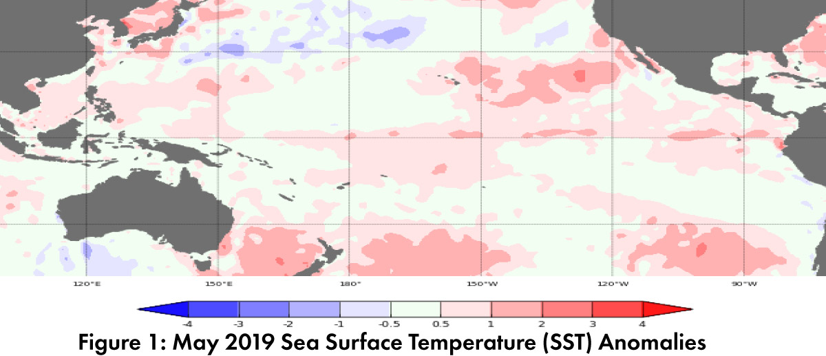
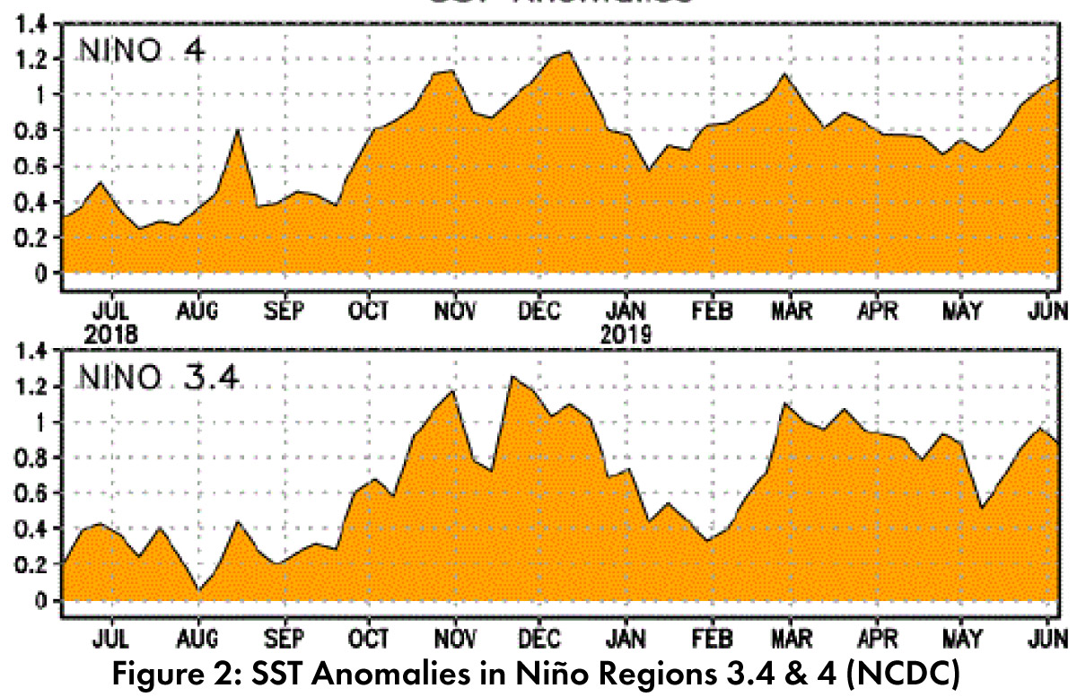
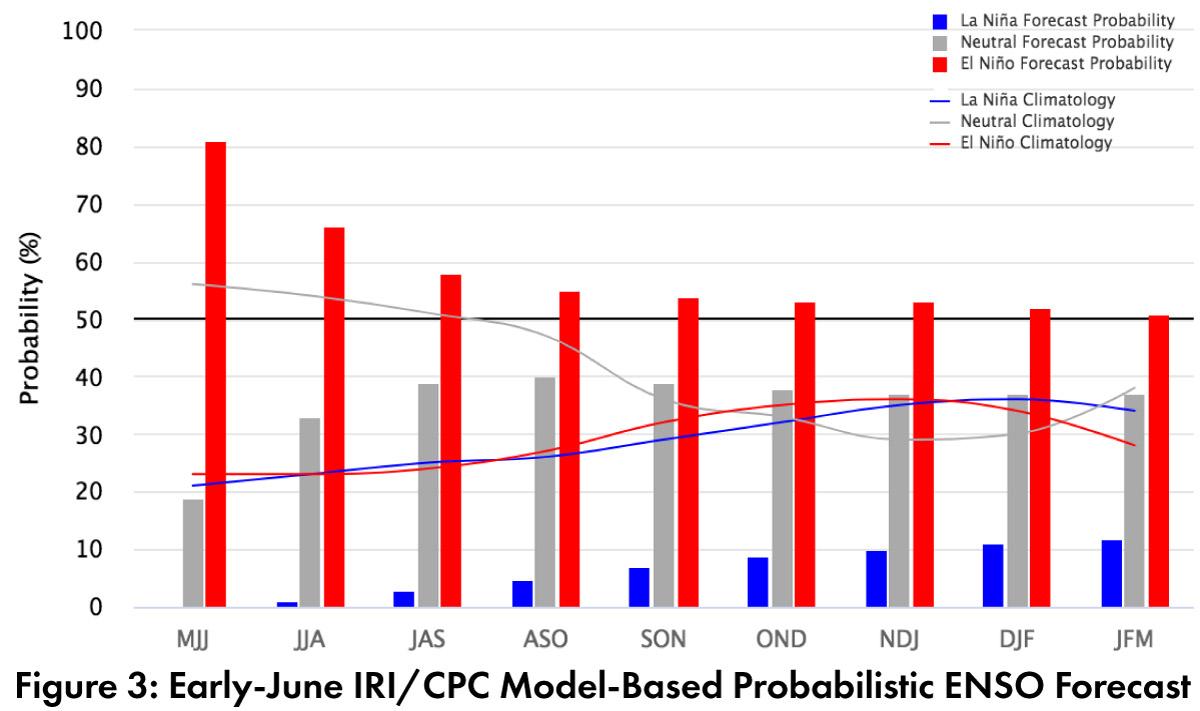
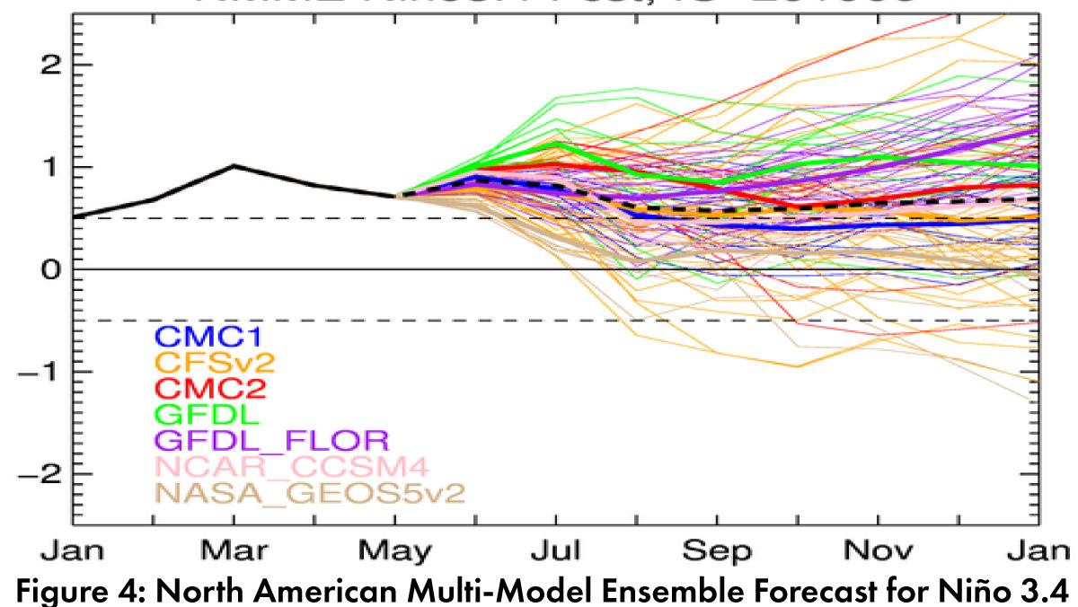
Forecast Roundup: Seasonal outlooks are based on the persistence of sea surface temperature (SST) anomalies consistent with a weak El Niño event (Figs. 1-2), along with the presence of other atmospheric and oceanic indicators (convective anomalies, sub-surface temperatures). On June 10, the Japanese Meteorological Agency (JMA) noted persistent SST anomalies along with atmospheric and sub-surface indicators of El Niño, and called for a 70-percent chance of these conditions continuing into summer, and a 60-percent chance to last into fall. On June 11, the Australian Bureau of Meteorology maintained their ENSO Outlook at watch status, calling for a 50-percent chance of an El Niño event in 2019. On June 13, the NOAA Climate Prediction Center (CPC) maintained their El Niño advisory based on the SST anomalies, along with convective anomalies and sub-surface temperatures. Their outlook dipped to a 66-percent chance of El Niño lasting through summer, and 50- to 55-percent of lasting through fall. On June 19, the International Research Institute (IRI) issued an ENSO Quick Look (Fig. 3), highlighting above-average SSTs and warm subsurface waters, and “some” atmospheric indicators consistent with El Niño. The North American Multi-Model Ensemble (NMME) points toward a weak El Niño lasting into fall 2019 (Fig. 4), with considerable spread based on uncertainty.
Summary: El Niño conditions are within the range of a weak event. Based on current models and forecasts, the likely trajectory is for these conditions to persist through summer, with increasing uncertainty and model spread heading into fall and winter. As reported last month, there are two associations of note. The first is enhanced northern pacific tropical storm activity, which could see tropical storms increase our warm season precipitation totals in direct ways (i.e. storms that push into the region) or that provide additional moisture and instability that enhances monsoon activity. This is more commonly seen during the latter half of the monsoon into Fall, and unlike last year with TS Bud, there has not been early season tropical storm activity that pushed moisture into the Southwest. The second association is tenuous given small sample sizes, but El Niño conditions over summer have been linked to a delayed onset of monsoon activity. This linkage appears to be influencing some seasonal forecasts and has been picked up in the media, but the science and our understanding of this link is still evolving. Big picture? El Niño sends mixed signals for seasonal outlooks and will keep us guessing regarding the timing and intensity of tropical storm activity and monsoon precipitation – in other words, a typical summer in the Southwest.
Online Resources
- Figure 1 - Australian Bureau of Meteorology - bom.gov.au/climate/enso
- Figure 2 - NOAA - Climate Prediction Center - cpc.ncep.noaa.gov
- Figure 3 - International Research Institute for Climate and Society - iri.columbia.edu
- Figure 4 - NOAA - Climate Prediction Center - cpc.ncep.noaa.gov


