SWCO ENSO Tracker - Feb 2017
Originally published in the Feb 2017 CLIMAS Southwest Climate Outlook
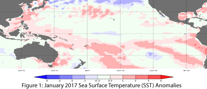
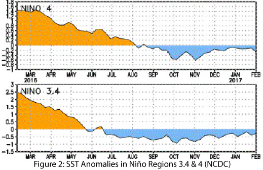
The La Niña event of 2016-2017 is officially over, with oceanic and atmospheric indicators of the El Niño-Southern Oscillation (ENSO) having returned to neutral conditions (Figs. 1-2). Neutral conditions are expected to remain in place for the next few months, but the usual difficulty in accurate forecasting that occurs in the spring means the current ENSO forecast includes a wide range of timing and uncertain outcomes. Most forecast agencies are predicting that ENSO-neutral conditions will remain in place through at least spring 2017, with a possible return of El Niño conditions sometime in mid-to-late 2017.
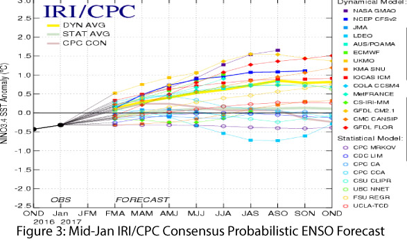
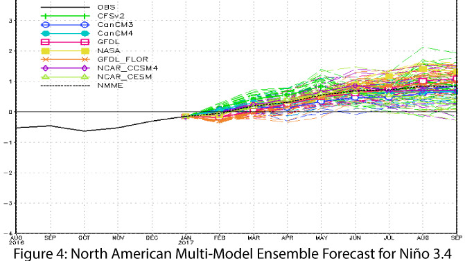
This forecast reflects the current understanding of ENSO patterns based on statistical models using data from past events, but until dynamical models (based on observations and conditions) are available later this spring and summer, these forecasts should be taken with a grain of salt. That said, a closer look at the forecasts and seasonal outlooks provides insight into the range of predictions for the rest of winter and the ENSO signal for the rest of 2017. On Feb. 9, the NOAA Climate Prediction Center (CPC) gave its final La Niña advisory, indicating oceanic and atmospheric conditions had returned to ENSO-neutral conditions. They forecast a 60-percent chance of ENSO-neutral conditions through summer 2017, and a 50-percent chance of El Niño conditions in the second half of 2017. On Feb. 10, the Japanese Meteorological Agency (JMA) declared that observed conditions, while generally indicative of a weak La Niña event, did not meet the JMA definition for a La Niña event. They forecast a 60-percent probability of ENSO-neutral conditions lasting through summer 2017. On Feb. 14, the Australian Bureau of Meteorology maintained an inactive status for its ENSO outlook, with “virtually all indicators close to average values,” and with warming oceanic conditions indicating neutral or El Niño conditions as the most likely outcome for 2017. On Feb. 16, the International Research Institute for Climate and Society (IRI) and CPC declared the La Niña over and “squarely in neutral,” and their forecast was split between dynamical models pointing towards El Niño and statistical models pointing towards neutral (Fig. 3). The North American Multi-Model Ensemble (NMME) characterizes the current model spread and highlights the variability looking forward to 2017. The NMME mean is forecast to remain ENSO-neutral through spring, but reaches the threshold of weak El Niño by summer (Fig. 4).
Last month’s joke about La Niña doing a great El Niño impersonation is still relevant, particularly as northern California and the Intermountain West have recorded heavy rain and snow, and portions of the Southwest are wetter than normal. While January in particular was wet, the cumulative cool season (Oct-Mar) precipitation totals will reveal the overall effects (if any) of the La Niña. Furthermore, the precipitation totals must be evaulated against the effects of elevated temperatures, given their impact on snowpack and water storage over winter, and on altered timing of streamflow during spring and summer. Thus, both factors are key to assessing downstream impacts on water resource management over the coming months and years, with both short-term (as evidenced by the Oroville Dam spillway damage) and long-term (i.e. water levels in Lake Mead) issues to consider.
Next month’s Southwest Climate Outlook will have a detailed recap of La Niña, but based on most criteria, it began in fall 2016 and ended in early February 2017. This event straddled the distinction between weak La Niña and ENSO-neutral conditions, highlighting the difficulty in classifying borderline conditions by categorical designation. This ambiguity was further demonstrated by the lack of complete agreement as to the existence or timing of the event by different agencies using different categorical thresholds.
 In the Southwest, a La Niña event is more likely than not to bring warmer- and drier-than-average conditions over the cool season, and La Niña years cluster on the dry end of seasonal precipitation distributions (Fig. 5), but weak La Niña events have a less pronounced relationship to reduced seasonal precipitation than stronger events. In fact, a weak La Niña event might not even stand out from the normal seasonal variation of typically dry southwestern winters. Nevertheless, the potential for impacts on regional streamflow and reservoir storage from any reduction in regional and western snowpack raised concerns about La Niña exacerbating drought in 2016-2017. Fortunately, La Niña’s tendencies have not come to pass, at least so far. Current snowpack, streamflow forecasts, and water resource management projections are optimistic (Fig. 6), with hope that this pattern lasts through winter and spring, and that elevated temperatures do not substantially affect snowpack or the timing of streamflow.
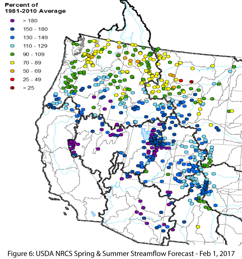
Image Credits:
- Figure 1 Australian Bureau of Meteorology http://www.bom.gov.au/climate/enso/index.shtml
- Figure 2 NOAA - National Climatic Data Center http://www.ncdc.noaa.gov/teleconnections/enso/
- Figure 3 International Research Institute for Climate and Society http://iri.columbia.edu/our-expertise/climate/forecasts/enso/
- Figure 4 NOAA - Climate Prediction Center http://www.cpc.ncep.noaa.gov/
- Figure 5 Climate Science Applications Program http://cals.arizona.edu/climate
- Figures 6 Natural Resources Conservation Service http://www.wcc.nrcs.usda.gov/