Dec 2016 CLIMAS Southwest Climate Outlook - Climate Summary
From the December issue of the CLIMAS Southwest Climate Outlook
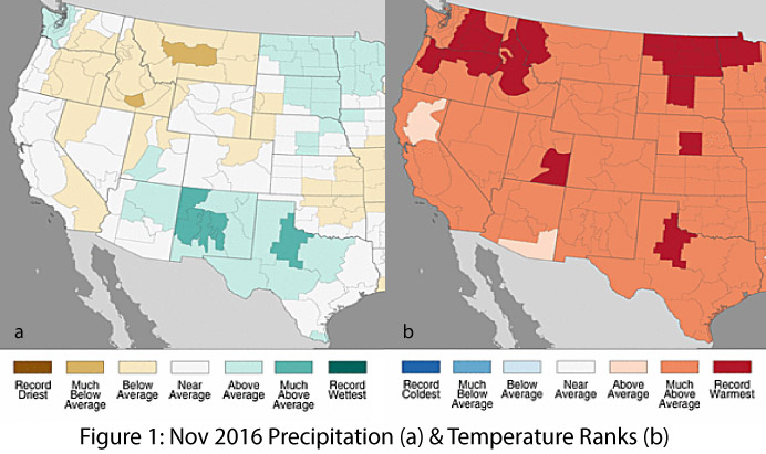
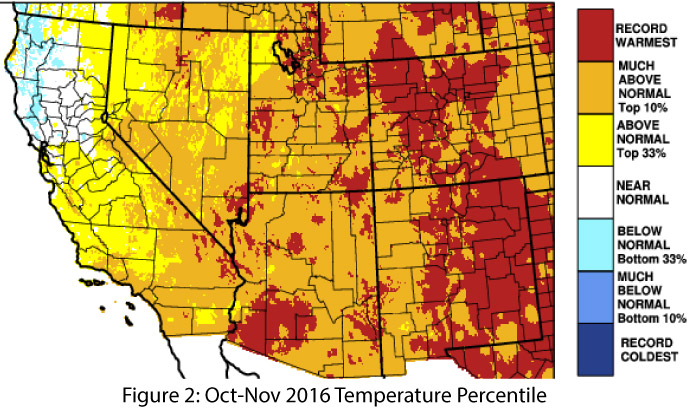
Precipitation & Temperature: November precipitation totals were average to above average in Arizona’s climate divisions, and above average to much above average in New Mexico’s climate divisions (Fig. 1a). November temperatures were much above average across most of Arizona and all of New Mexico (Fig. 1b). This continued a trend of warm temperatures this fall, with parts of Arizona and New Mexico recording record warm temperatures in October and November (Fig. 2). Very little precipitation has fallen in December. This is not unexpected, as the Southwest generally receives limited precipitation between the end of the monsoon and early fall tropical storm activity and the uptick in precipitation in mid-winter into spring (when much of the cool season precipitation falls in the region). Temperatures in December have been mostly above normal in Arizona and western New Mexico, with cooler-than-normal temperatures in eastern New Mexico (Fig. 3). The upcoming polar vortex in the upper midwestern and eastern U.S., in addition to atmospheric river activity off the U.S. Pacific Coast, should shift this pattern in the latter half of December.

Snowpack & Water Supply: Warm temperatures continue to limit early season snowpack across the West, and snow water equivalent (SWE) values are below average across much of the region. As of December 14, most of the stations in Arizona and New Mexico were at or below 50–75 percent of normal, while stations in Colorado and Utah recorded 50–90 percent of normal and 90–125 percent of normal, respectively (Fig. 4). There is ongoing concern that continued drought conditions may lead to water supply restrictions (see Reservoir Volumes).
Drought: Long-term drought conditions persist across the Southwest (Fig. 5). According to the December 13 U.S. Drought Monitor, most of Arizona is designated as abnormally dry (D0) or experiencing moderate drought (D1). The far southwestern corner of the state is designated as experiencing severe drought (D2), reflecting the persistent multi-year drought conditions extending from central and Southern California. In New Mexico, most of the northern half of the state and pockets along the U.S.-Mexico border are designated as abnormally dry (D0).

ENSO & La Niña: Borderline weak La Niña conditions are present but are declining, with a likely return of neutral conditions during winter 2016–2017. The decline that most models and forecasts identify could limit the influence of La Niña on weather in the Southwest, although weak La Niña events have been less reliably dry compared to moderate and strong La Niña events. Regardless of the ENSO signal, the climate of the Southwest is inherently dry. The cool season already receives relatively low precipitation totals in a normal year, so La Niña conditions—weak or otherwise—are more likely than not to increase the chances of a drier-than-average winter. This is a concern, given the multi-year drought currently underway in the Southwest, along with the looming possibility of water restrictions in coming years if Lake Mead levels are forecast to drop below the 1,075-foot elevation threshold.
Precipitation & Temperature Forecasts: The December 15 NOAA Climate Prediction Center’s outlook for January calls for increased chances of below-average precipitation and above-average temperatures. The three-month outlook for January through March also calls for increased chances of below-average precipitation (Fig. 6, top) and above-average temperatures (Fig. 6, bottom).

