El Niño Tracker - July 2015
El Niño conditions continue for a fifth straight month, and at this point, forecasters are relatively bullish that we are witnessing the development of a moderate-to-strong event that could rival 1997 in absolute magnitude later this year. The most recent outlooks from various sources offer a consistent cluster of forecasts calling for a clear El Niño signal that is maintained or even strengthens well into early 2016. Forecasts focused on the persistence of sea-surface temperature (SST) anomalies (Figs.1 - 2) along with weakening trade winds, ongoing convective activity in the central and eastern Pacific, and El Niño-related ocean-atmosphere coupling.
On July 7, the Australian Bureau of Meteorology maintained its tracker at official “El Niño” status, identifying a strengthening El Niño (in part due to increased tropical storm activity), and projecting the event as likely to persist through the end of 2015 and into 2016. On July 10, the Japan Meteorological Agency identified strengthening El Niño conditions in the equatorial Pacific, and forecast that the current El Niño conditions were likely to last until winter. On July 9, the NOAA-Climate Prediction Center (CPC) extended its El Niño advisory with a greater than 90-percent chance that El Niño will continue through winter 2015-2016, and an 80-percent chance it will last into early spring 2016. It cited the increasingly positive SST anomalies in the central and eastern Pacific and ongoing ocean-atmospheric coupling and convection activity as indicators of an ongoing and strengthening event (Fig. 3). On July 16, the International Research Institute for Climate and Society (IRI) and CPC forecasts indicated continued strengthening of El Niño through 2015 and into 2016, with a moderate event likely becoming a strong event by summer or early fall and lasting into early 2016. The North American multi-model ensemble currently shows a moderate event extending through early summer, with potential for a strong event by mid-summer or early fall (Fig. 4).
It is clear that we are in the midst of an ongoing and strengthening El Niño event. If this event remains on the current trajectory, it could surpass the strongest El Niño events of recent decades (1997 in particular), with implications for both Southwest and global communities.
In May and early June, we witnessed exactly the sort of patterns we might expect to see in Arizona and New Mexico under El Niño conditions—above-average precipitation and below-average temperatures. If El Niño persists into winter 2015-2016, particularly if it remains a moderate-to-strong event, we would likely continue to see above-average precipitation in the Southwest (Fig. 5). Although the presence of El Niño conditions often has been associated with a delay in the start of the monsoon, this year the monsoon began early. However, a resurgent El Niño signal now may be pushing back and could work to disrupt the monsoon ridge, leading to one or more ‘breaks’ in the monsoon. The event could also lead to a repeat of 2014’s above-average eastern Pacific tropical storm season, when conditions favorable to El Niño were thought to be driving increased tropical storm activity in the Southwest in September and October.
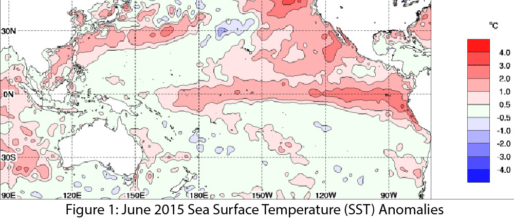
Image Source - Australian Bureau of Meteorology
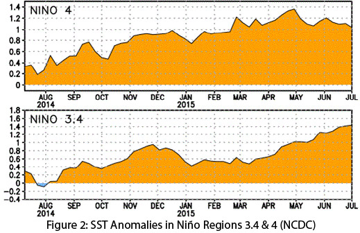
Image Source - National Climatic Data Center
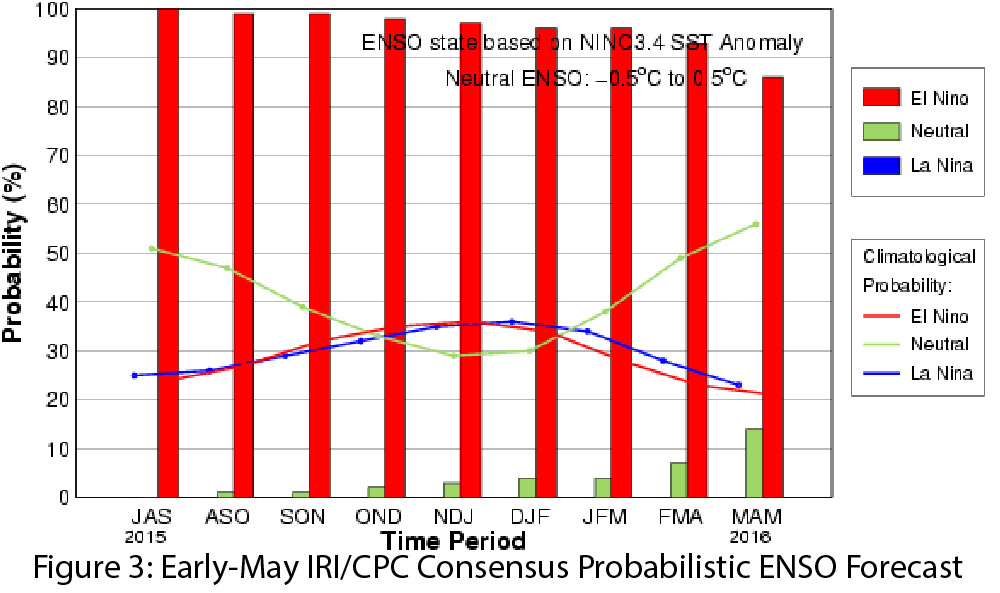
Image Source - International Research Institute for Climate and Society
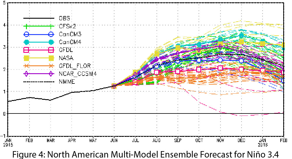
Image Source - NOAA - Climate Prediction Center
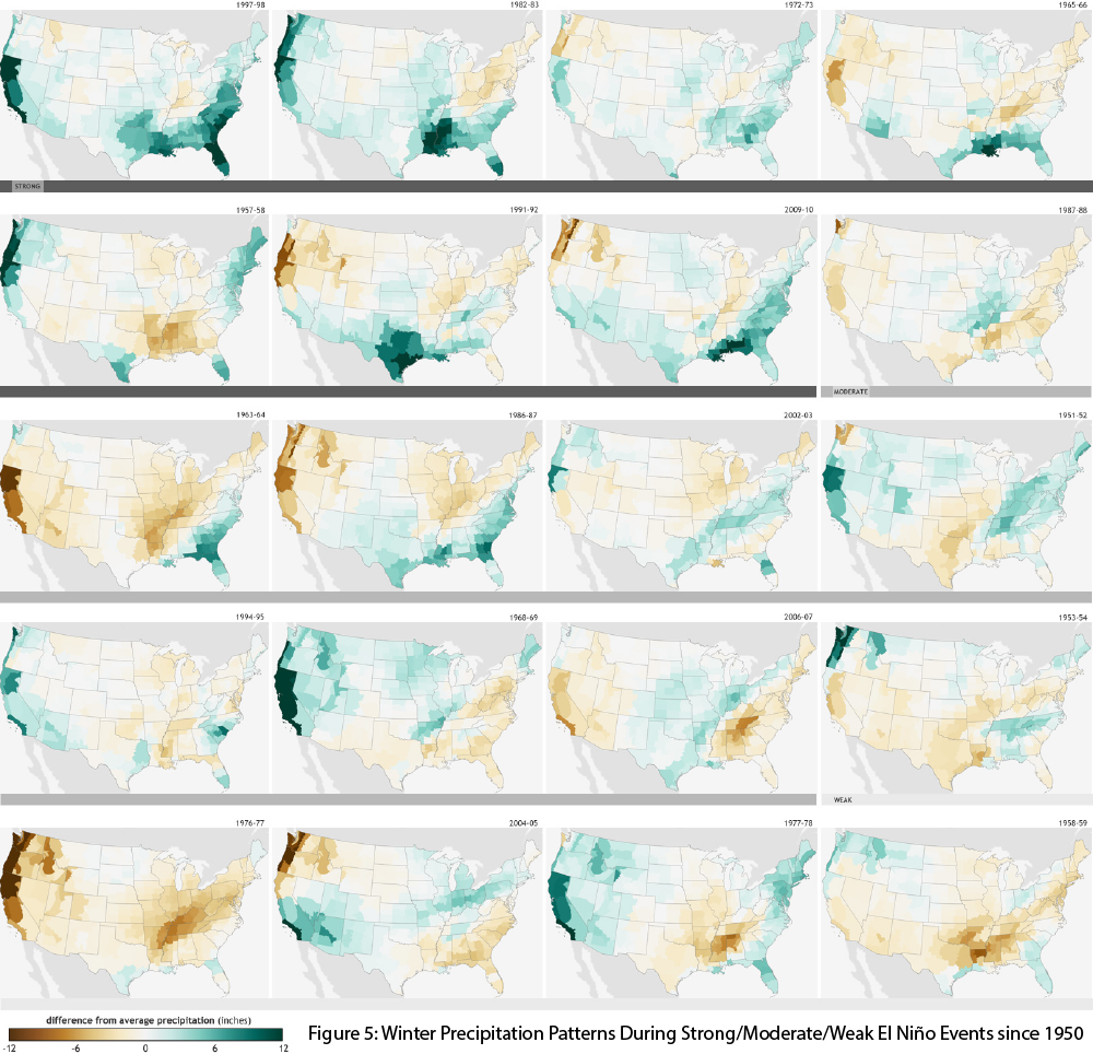
Image Source - NOAA Climate.gov