Southwest Climate Outlook June 2015
Originally Published in the June 2015 CLIMAS SW Climate Outlook (SWCO)
Precipitation: In the past 30 days, most of New Mexico and much of northern Arizona recorded well-above-average precipitation (Fig. 1). Climatologically, we are in one of the drier times of year for the Southwest, so this precipitation and humidity (mostly tied to early season Pacific tropical storm activity) helped tamp down fire risk. This respite was short-term however, as water-year observations since October 1 reflect persistent and ongoing drought conditions, with most of the western U.S. recording well-below-average precipitation (Fig. 2). Notable exceptions are New Mexico, Colorado, Wyoming, and Montana, but with most recent precipitation falling on the eastern side of the Continental Divide.
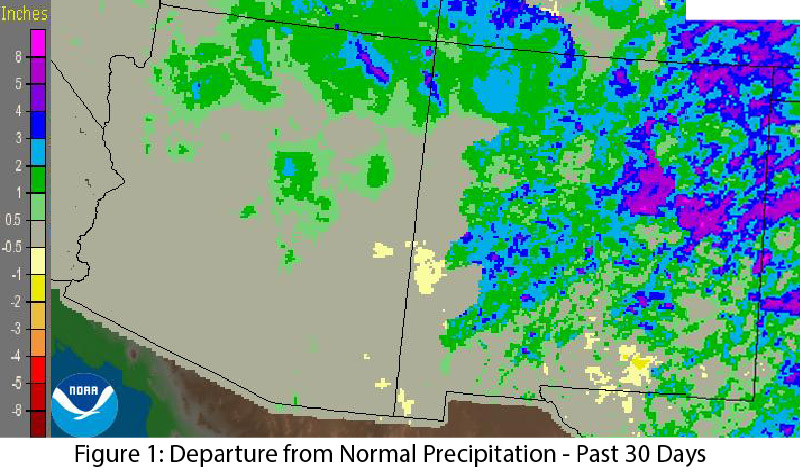
Image Source - NOAA/NWS - Advance Hydrologic Prediction Service
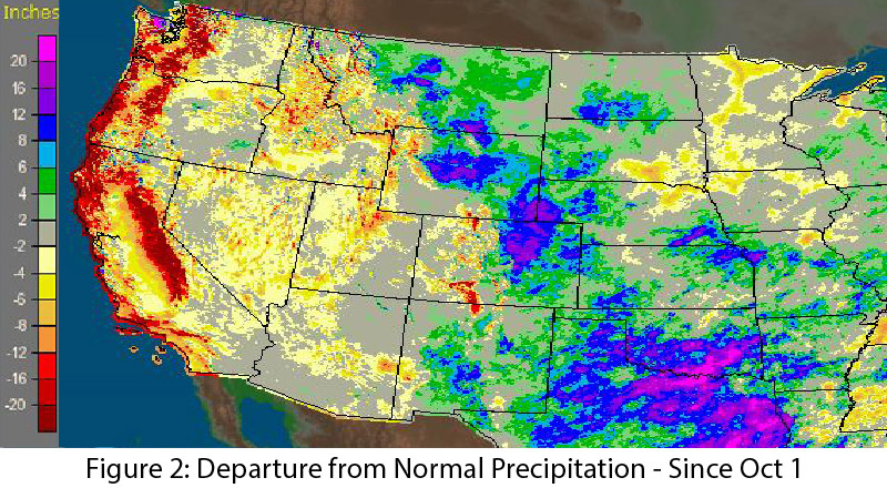
Image Source - NOAA/NWS - Advance Hydrologic Prediction Service
Temperature: Tropical storm activity led to unseasonably mild and pleasant conditions across the Southwest, with temperature anomalies across much of Arizona and New Mexico between 2 and 6 degrees below average during the past 30 days (Fig. 3). But by mid-June, the Southwest had returned to more typical hotter and drier temperature and humidity patterns. These conditions are likely to persist until the monsoon fires up, which may be delayed by El Niño conditions.
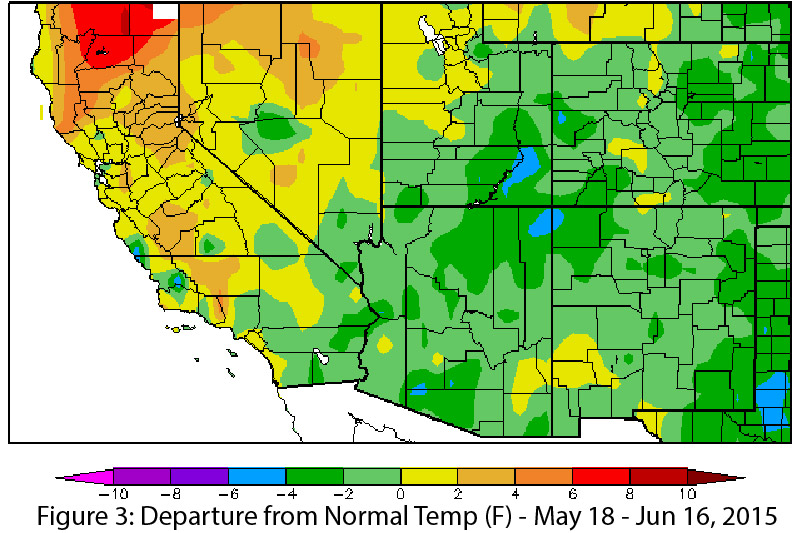
Image Source - High Plains Regional Climate Center
Snowpack/Streamflow: At this point in the season (and after a relatively warm winter), snow is absent across much of the West. The recent unseasonably cool and wet conditions led to some anomalous snow water equivalent (SWE) readings in Colorado and Utah (Fig. 4), but it remains to be seen if this will have any long-term effects on water supply or streamflow. Streamflow forecasts reflect generally warm and dry winter conditions, with below-average forecasts across most of the western U.S. (Fig. 5), save for a few locations that saw late-season spikes in storm activity.
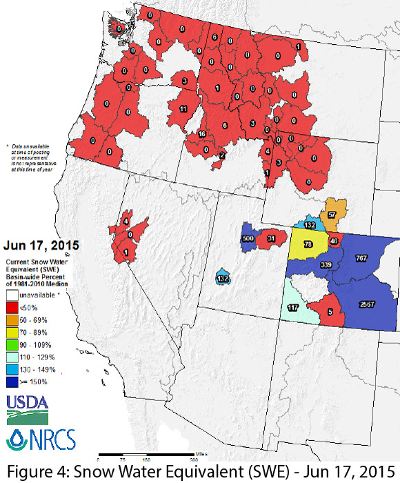
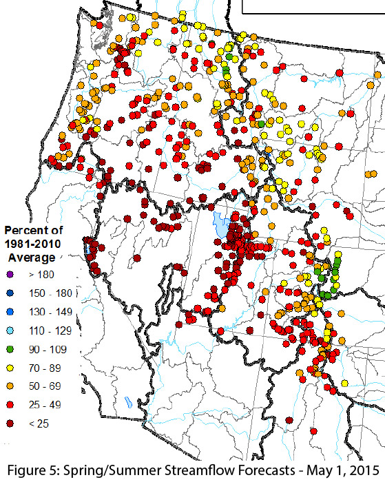
Image Source - Natural Resources Conservation Service
Drought & Water Supply: The U.S. Drought Monitor highlights drought conditions across the West, with particularly severe conditions in California and Nevada. Arizona and New Mexico are still grappling with the impacts of years of accumulated drought, and the monitor emphasizes long-term drought conditions across Arizona and western New Mexico.
Wildfire: Mild spring weather, above-average precipitation and above-average relative humidity have reduced wildfire risk in Arizona and New Mexico for most of this wildfire season thus far, but recent elevated temperatures and decreased humidity could change conditions quickly. The current short-term forecast calls for increasingly hotter, drier, and breezy conditions, especially in southern Arizona (Fig. 6). This could increase fire risk across the region, especially given the abundance of fine fuels stemming from above-average tropical storm activity late last fall. In the past week or so, we have already seen a number of lightning ignitions, although to date, fire managers are allowing these to burn to reduce fuel loads, further highlighting the beneficial impact of the extended period of cool and wet late-spring weather.
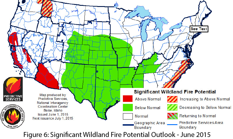
Image Source - National Interagency Coordination Center
Precipitation & Temperature Forecasts: The June 18 NOAA-Climate Prediction Center seasonal outlook predicts above-average precipitation for much of the Southwest and most of the Intermountain West this summer, with California, western Nevada, and southwest Arizona as notable exceptions. Temperature forecasts are split, with elevated chances for above-average temperatures along the West Coast and into Arizona (and most of the western U.S.), and increased chances for below-average temperatures in the midwestern U.S. and extending into eastern New Mexico (Fig. 7)
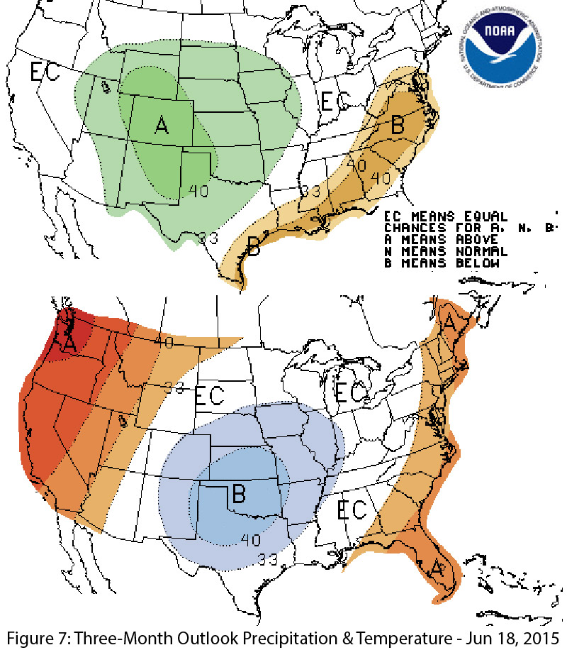
Image Source - NOAA/NWS - Climate Prediction Center