2015 El Niño Tracker
Originally published in the May 2015 CLIMAS SW Climate Outlook
El Niño continued for a third straight month, with no signs of weakening or dissipating. Forecasts keyed in on persistent sea surface temperature (SST) anomalies (Figs. 1–2), along with weakening trade winds, ongoing convective activity, and El Niño-related ocean-atmosphere coupling. If these conditions continue, we are likely to see the effects of a moderate El Niño event–or stronger if conditions continue to strengthen. Spring forecasts have a higher degree of uncertainty, owing to the so-called spring predictability barrier, a likely source of vacillations in recent forecasts.
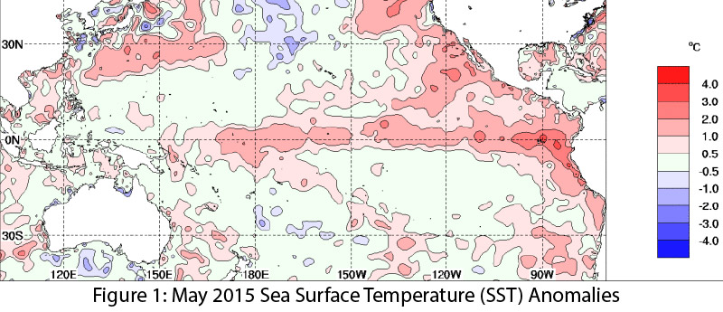 Image Source - Australian Bureau of Meteorology
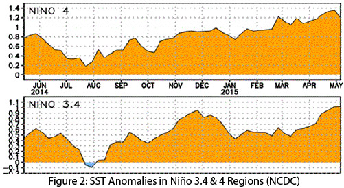 Image Source - NOAA-National Climatic Data Center
Current forecasts offer a consistent and bullish forecast compared to last month, when they were integrating mixed signals regarding the strength of El Niño. On May 12, the Japan Meteorological Agency reversed course with an observation that strengthening El Niño conditions in the equatorial Pacific reflected an ongoing El Niño event that was likely to last through at least fall 2015. On May 12, the Australian Bureau of Meteorology upgraded its tracker to official El Niño status, identifying persistent SST anomalies, weak trade winds, and increasing ocean-atmospheric coupling serving as indicators this El Niño event was strong enough to extend into 2015. On May 14, the NOAA-Climate Prediction Center (CPC) extended its El Niño advisory with a 90 percent chance that El Niño will continue through summer 2015 and an 80 percent chance the event will last through 2015 (Fig. 3). The CPC pointed to positive SST anomalies, along with ongoing ocean-atmospheric coupling and dateline convection activity, as indicators of a weak to moderate El Niño event that will likely continue for most of 2015. On May 21, the International Research Institute for Climate and Society (IRI) and CPC forecasts confirmed we are in the midst of an El Niño event that appears to be strengthening, with the current forecast suggesting a moderate to strong El Niño event persisting into 2016. The North American multi-model ensemble shows a moderate event extending through the spring, with potential for a strong event by summer or early fall (Fig. 4).
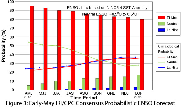 Image Source - International Research Institute for Climate and Society
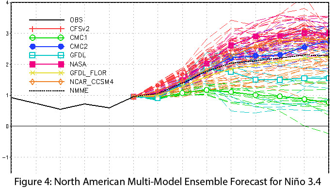 Image Source - NOAA-Climate Prediction Center
After a series of fits and starts, the pieces finally seem in place for the El Niño event forecasters expected to start last year. This is partially evidenced by the recent above-average precipitation and below-average temperatures in Arizona and New Mexico in late April and early May—exactly the sort of springtime weather we might expect to see if El Niño conditions were present and affecting our weather patterns. If the event persists into fall and winter 2015, and particularly if it remains a moderate to strong event, we will likely see patterns of above-average precipitation in the Southwest. There is also the possibility of a repeat of the 2014 tropical storm season, in which conditions favorable to El Niño were thought to have driven the increased tropical storm activity in the Southwest.