El Niño Tracker - January 2015
Originally published in the January 2015 Southwest Climate Outlook (SWCO)
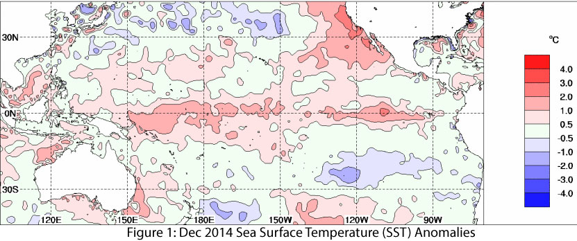
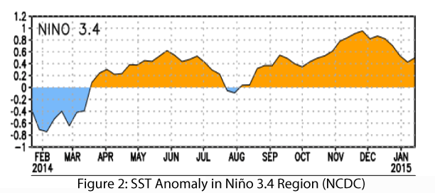
Just when it looked like we were getting a more definitive answer regarding El Niño, ongoing lack of cooperation on the part of the atmosphere continues to muddy forecasts moving into 2015. Sea surface temperatures (SSTs) remain elevated across much of the equatorial Pacific Ocean (Fig. 1), and while temperature anomalies in the Niño 3.4 region are within the range of a weak El Niño event, they have declined in the past month (Fig. 2). It is a common refrain in forecast bulletins that a lack of coupling between ocean and atmosphere is responsible for decreased confidence in an El Niño event this winter. Additionally, a lack of temperature gradient along the equatorial Pacific and little in the way of El Niño wind patterns further reduce confidence that a stronger event is on the horizon.
Source: Australian Bureau of Meteorology
Source: NOAA-National Climatic Data Center
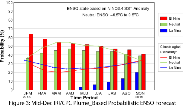
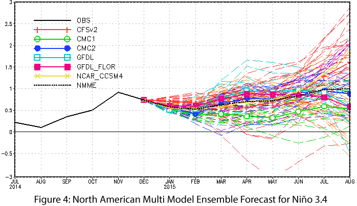
The most recent forecasts remain in a cautious holding pattern, pending the emergence of a more decisive signal. On Jan. 8, the NOAA-Climate Prediction Center (CPC) issued another El Niño Watch, assigning a 50 to 60 percent probability that an El Niño would form in the next two months, with forecaster consensus that this would be a weak event extending into late winter or early spring. On Jan. 9, the Japan Meteorological Agency continued its assessment that El Niño conditions had been present in the equatorial Pacific for multiple months but noted uncertainty as to the length or intensity of an El Niño event, with emphasis on a weak event that would transition to ENSO-neutral by early spring. On Jan. 15, the International Research Institute for Climate and Society (IRI) and CPC scaled back the probability of an El Niño formation to approximately 60 percent (Fig. 3) but indicated SST anomalies were sufficient enough to suggest a weak El Niño event was likely underway and would last through spring 2015. On Jan. 20, the Australian Bureau of Meteorology actually shifted its El Niño tracker status to neutral, given the fade in SST anomalies and lack of clear atmospheric signal. The North American multi-model ensemble shows a weak event that extends into summer (Fig. 4).
Source: International Research Institute for Climate and Society
Source: NOAA-Climate Prediction Center
Vacillations in forecast percentages prompted the forecast community to describe current conditions as “El Limbo.” Despite lack of official status, El Niño-like conditions may already be driving winter patterns, and seasonal precipitation forecasts indicate an enhanced chance for above-average precipitation this winter across the Southwest, although confidence in this forecast is partially contingent on the strength of these El Niño conditions. Impacts associated with weak El Niño events are generally less certain than those of a moderate or strong event, with past weak events bringing both dry and wet conditions to the Southwest U.S. during the winter. Ultimately, the above-average tropical storm season and the humidity that remained in the region may be indicative of the effect of El Niño-like conditions, even in the absence of a formal designation, and give some idea that the regional patterns have shifted in favor of El Niño formation.