Notes From the Field: Preparing for Climate Change Along the US-Mexico Border
 On September 10-11, 25 scientists and natural resource managers met at the offices of the International Boundary and Water Commission (IBWC), in El Paso, Texas. Their goal was to use strategic scenario planning techniques to gain insight into environmental and natural resource planning under highly uncertain conditions. Participants included climatologists, meteorologists, geologists, hydrologists, ecologists, biologists, and environmental economists, representing a range of U.S. and Mexican federal agencies, state agencies, universities, and non-governmental organizations.
The workshop was organized by an ad hoc consortium of partners that consisted of:
- Myself (on behalf of CLIMAS and the North American Climate Services Partnership [1])
- Aimee Roberson (Science Coordinator, US Fish & Wildlife Service, of the Department of the Interior’s Desert Landscape Conservation Cooperative)
- Jeffery Bennett (Physical Scientist with Big Bend National Park),
- David Brown (CLIMAS alumnus and Climate Services Director for NOAA’s Southern Region), and
- Mark Briggs (Hydrologist with the World Wildlife Fund’s Chihuahuan Desert Program).
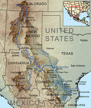
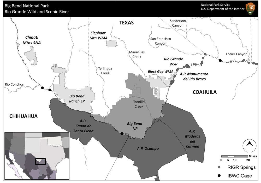
The workshop focused on riparian zones and adjacent ecosystems in the Big Bend reach of the river, including the Rio Grande Wild and Scenic River, and the Monumento Natural Río Bravo del Norte en Mexico. During the two-day workshop, participants were briefed on the climate, hydrology, and ecology of the region.
Workshop Goals
- Introduce participants to scenario planning methods for dealing with situations of high uncertainty—especially with respect to climate—and making use of climate information in decision making
- Foster a spirit of collaboration and build bilateral teams for ongoing planning,
- Exchange knowledge with regional risk managers about decision making needs, climate forecasts and projections, decision contexts, constraints, and risk tolerance,
- Increase awareness of regional efforts, in order to identify areas of mutual interest and facilitate coordination and collaboration.
Dr. Holly Hartmann (Holly C. Hartmann Consulting)introduced workshop participants to strategic scenario planning techniques used by industry, the military, and some federal agencies, and facilitated most of the scenario planning exercises [2]. These techniques are focused on addressing factors outside the control of resource managers, such as climate or economic fluctuations, and were designed to help managers make informed decisisons despite considerable uncertainty.
NOAA scientists from the National Climatic Data Center, NOAA’s Southern Region office, and the El Paso Weather Forecast Office, worked with regional and state climatologists, including CLIMAS’s Dave Dubois (New Mexico State University), to assess plausible future conditions despite highly variable climate factors, including summer precipitation totals and the date of onset for the North American Monsoon (NAM). Texas State Climatologist, John Nielsen-Gammon (also an affiliate of the SCIPP RISA), laid out key facts about the regional climate:
- The region receives the vast majority of its annual precipitation during the summer season,
- Regional precipitation variability is exceptionally high, and
- Aside from temperature-related soil moisture decreases, there is very high uncertainty associated with climate model projections of future precipitation.
During wide-ranging discussions about the uncertainty of future climate conditions, we considered possible eastward and westward shifts in the center of action of the NAM in the border region, the timing, intensity, and amount of summer precipitation, the severity and extent of regional drought, and the impact that these factors might have on river hydrology, especially sediment flows [3].
What We Accomplished
Participants developed four preliminary scenarios focusing on:
- Uncertainty regarding the amount and timing of future precipitation;
- How future cooperation between stakeholders amplifies or moderates future environmental challenges; and
- The degree to which implementation of management actions is based on correct scientific understanding of future environmental changes.
Discussion amongst participants revealed a need for more cross-border collaboration to increase preparedness and coordination, and to achieve positive outcomes in the face of future climate conditions such as sustained drought or increased flash flood frequency.
Toward the end of the workshop, IBWC Commissioner Edward Drusina, took time from his busy schedule to address the participants. He emphasized the need to build capacity, on both sides of the international border, for timely and informed responses to the challenge of drought and extreme climate variations. He urged participants to make it a priority to communicate their knowledge to society.
Key outcomes of the workshop:
- Increased capacity in the Rio Grande-Río Bravo bi-national region for using scenario planning to address uncertainty in future climatic conditions;
- Preliminary climate change scenarios for the region, including plausible scenarios of future environmental and social impacts; and
- Enthusiasm for continued and more detailed and deliberate bi-national discussions of these issues.
Next steps in this process:
- Expand scenario planning methods to a broader stakeholder group interested in the region, and
- Continue the scenario planning process by exploring existing and alternative scenarios in greater depth, and developing a portfolio of potential adaptation actions and strategies.
These steps will engage additional participants using workshops in Mexico and the U.S.
The Desert LCC is also looking to apply the climate scenario methodology presented at this workshop to landscape conservation planning and design.
Acknowledgment: This blog post benefited greatly from input by the workshop organizing committee, mentioned above
Footnotes:
- About the North American Climate Services Partnership (NACSP) - In 2012, the weather services of Canada, the United States (NOAA), and Mexico signed a statement of intent to facilitate the exchange of information, technology and management practices related to the development and delivery of climate and water information for North America. The goals of NACSP are similar to those of CLIMAS: to foster the development of partnerships with the users of climate information, to enhance and improve the use of climate information by decision makers, and to create opportunities to share lessons learned from pilot projects and research. In 2013, yours truly was designated the co-chair of the Rio Grande/Rio Bravo pilot project. More information about the NACSP.
- Hartmann's ongoing work on scenario planning and decision support has been pivotal for land management agencies such as the National Park Service and the Bureau of Land Management.
- During the last 50 or more years, sediments have been accumulating in the Big Bend reach of the Rio Grande; this has caused a degradation of habitat for fish species and other animals and plants.
Image Credit:
- Figure 1: US/Mexico Region - Source: Mark Briggs - World Wildlife Fund
- Figure 2: Big Bend National Park & Rio Grande Wild and Scenic River - Source: Billie Brauch vs. Jeffery Bennett - National Park Service - US Dept of the Interior.