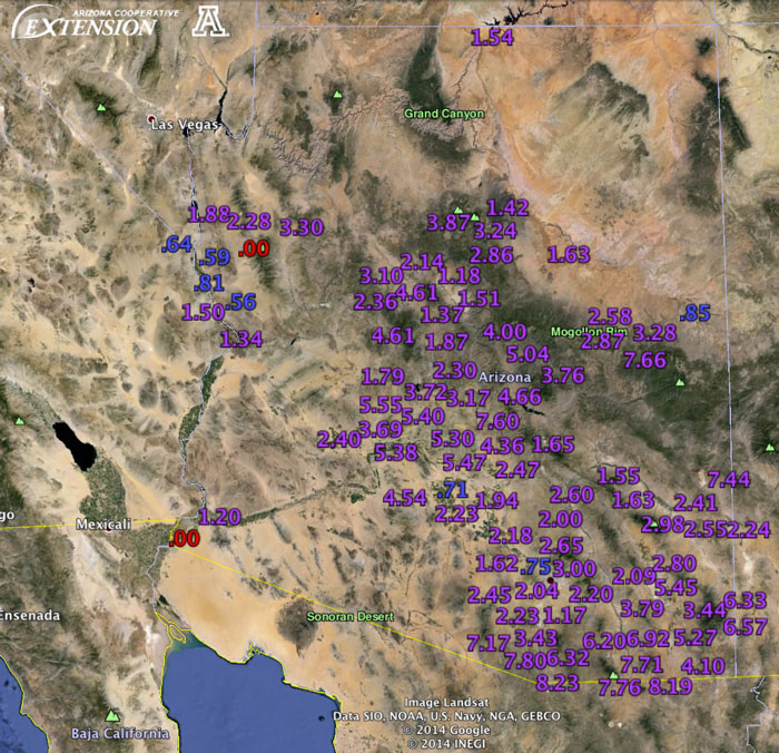
Notes from an Applied Climatologist - Sept 2014 Rainlog Climate Summary
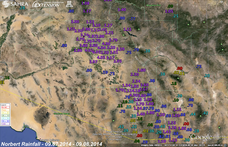
September turned out to be quite a month as far as extreme monsoon season weather across Arizona. The month started out rather quiet as the monsoon ridge of high pressure weakened and a trough of low pressure to the north ushered in dry air from the west across the state. This suppressed thunderstorm activity for several days until the monsoon ridge pushed back north helping to bring low level moisture back into the region. At the same time Hurricane Norbert was moving along the west coast of Mexico towards the southern end of the Gulf of California. By September 7th, Norbert helped spark a deep surge of moisture up the Gulf of California into the low deserts of Arizona. This sopping wet atmosphere turned into several rounds of heavy rain across both the Phoenix and Tucson metro areas breaking several daily precipitation records for these areas. Many Rainloggers in Mesa, Tempe and Chandler near Phoenix reported totals ranging from 4 to over 6 inches with this rain event. Tucson Rainloggers also reported 2 to 4 inches of total precipitation with this event. Widespread flash flooding crippled both of the metro areas and near flood flows were observed on several of the main water courses in the Tucson area.
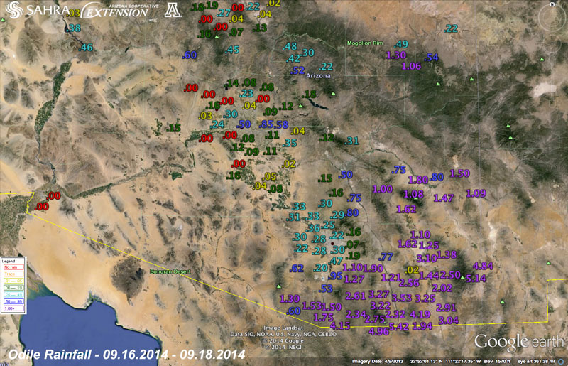
If that weren’t enough excitement for the month, a second hurricane impacted the region although directly this time later in the month. Hurricane Odile took a similar path to Norbert early on, but turned more northerly striking the southern tip of the Gulf of California on September 15th and traveling north along the spine of Baja California creating wide swaths of wind and flooding damage in its wake. Odile’s path north helped usher in additional moisture to the low deserts of Arizona which raised the risk of flash flooding across the region. Of even more concern was the prospect of the circulation remnants passing right over southern Arizona which raised the risk even further of widespread flooding rains. Ultimately, the remnants of Odile tracked further south than expected bringing most of the flooding rains to northern Mexico where precipitation reports in excess of 7” were common. Far southeast Arizona in Cochise County was not spared by Odile, though. Many Rainloggers from Sierra Vista to Douglas to Portal reported precipitation totals from 3 to over 5 inches with this event. Flash flooding sparked by Odile in the Chiricahua Mountains ripped through the small town of Portal and destroyed a Forest Service road critical for the region.
A cold front on the 27th was the close out event for the 2014 monsoon season, which sparked several rounds of severe thunderstorms across the state with damaging winds and flash flooding reported in central and northern parts of the state. Rainloggers in Prescott reported 1 to almost 3 inches with these thunderstorms as they moved through the region.
Overall September was unusually wet over the low deserts and near to even below average across higher elevations and across much of the plateau of northeastern Arizona. The monsoon season as a whole officially ended on September 30th with much the same pattern across the state with the much of western and central Arizona observing above-average precipitation and the northeast corner of the state observing less activity and below-average precipitation. Short-term drought conditions improved in some of these areas that received above-average precipitation, but longer-term drought conditions persist across the region.
Michael Crimmins is an Associate Professor and Climate Science Extension Specialist in the Department of Soil, Water and Environmental Science