Notes from an Applied Climatologist: East/West Cold/Hot Dichotomy Q&A
Originally published in Feb 2015 CLIMAS Southwest Climate Outlook:
Why has it been so cold on the East Coast, and so warm in the Southwest? Where does this fit into climatic patterns? And is this extraordinary or just variability?
The weather pattern across the U.S. has been pretty extreme over the past weeks, with record cold and snow across the East and record to near-record warmth in the West. Why is the country so divided? In short, a wavy jet stream is to blame (Fig. 1). This high-altitude stream of fast-moving winds has been carving a circuitous path around the globe for much of the winter. The path of the winter mid-latitude jet stream around the globe (in both hemispheres) can give a good indication of where storms are tracking and where warm and cold spots at the surface are emerging. If the jet stream gets stuck in any position, then places getting storms can continue to see a parade of storms, while warm and dry places stay warm and dry.
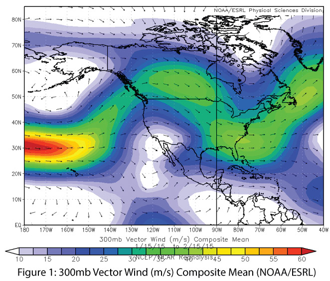
Image Source - NOAA-Earth Systems Resarch Laboratory (ESRL)
This winter, the mid-latitude jet stream in the Northern Hemisphere has been very wavy, or meridional [1], with ridges—large-scale bulges—to the north and troughs to the south. Ridges are associated with warm and dry conditions, while troughs are associated with cold and possibly snowy or rainy conditions. Over the past several weeks, this warm West/cold East pattern has dominated, with a persistent ridge of high pressure across the West and a very cold trough across the East (Fig. 2). Last year, similar conditions drove California and much of the Southwest deeper into drought and unleashed record-setting cold [2] in the eastern U.S. This year, these conditions have broken down on occasion, allowing for storms to bring some precipitation to the West and for the East to warm up for brief periods.
Researchers are trying to determine why this dichotomous pattern has emerged and persisted over the past couple of years. Some climate scientists propose that a warming Artic and declining sea ice [3] are contributing to an increasing frequency of wavy and stuck jet stream events. Other scientists argue that warming water [4] in the tropics and shifts in tropical convection are at play in impacting the winter jet stream pattern. This winter appears to be a complex interaction of many different factors [5] and will be studied in more detail over the coming year to see how it fits into these active areas of research.
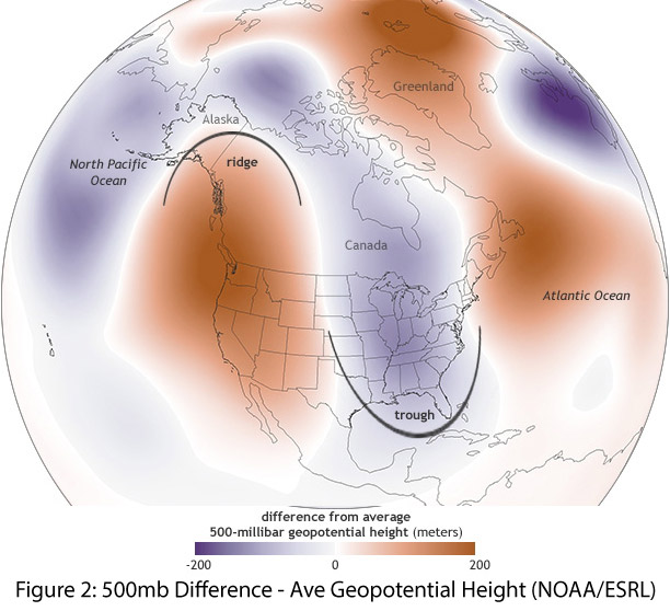 Image Source - NOAA-ESRL & Climate.gov
Additional Resources
- Meridional: In meteorology, a flow, average, or functional variation taken in a direction that is parallel to a line of longitude; along a meridian; northerly or southerly; as opposed to zonal.
- U.S. temperature extremes and the polar jet stream
- Evidence for a wavier jet stream in response to rapid Arctic warming
- Record-breaking winters and global climate change
- Synoptic Discussion - January 2015