SWCO ENSO Tracker - April 2017
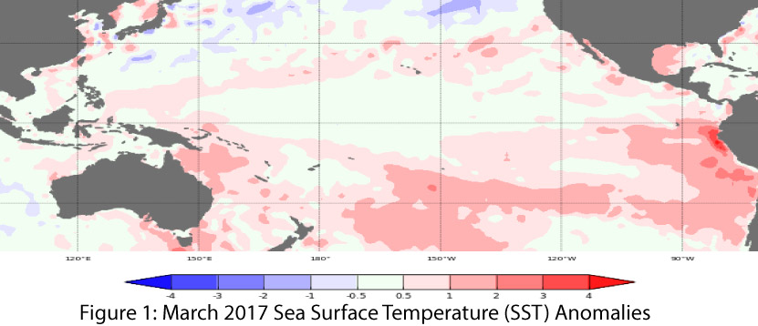
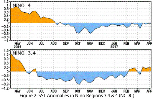
Similar to last month, oceanic and atmospheric indicators of the El Niño-Southern Oscillation (ENSO) are in the range of neutral (Figs. 1-2), and these conditions are forecast to last through the spring and summer. Most forecasts and outlooks indicate that El Niño conditions could return in mid-to-late 2017, but these assessments come with the annual caveat of increased uncertainty associated with the “spring predictability barrier”, during which time the specifics regarding the possibility, timing, and intensity of an El Niño event are elusive. At any rate, the models and forecasts indicate a near-zero probability of La Niña in 2017, leaving forecasters to decide between the probability of neutral or El Niño conditions in later 2017.
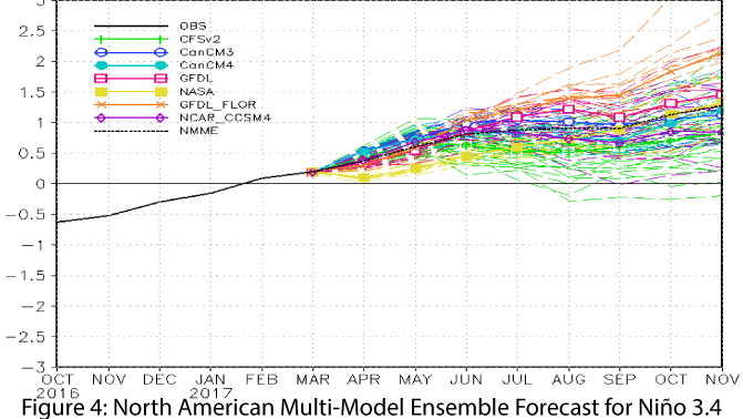
The various forecasts provide insight into the range of predictions for the remainder of spring and the ENSO signal for the rest of 2017. On April 10, the Japanese Meteorological Agency (JMA) identified a continuation of ENSO-neutral conditions, with a 50-percent chance of El Niño conditions by the end of summer, but flagged high uncertainties in the models. On April 11, the Australian Bureau of Meteorology maintained their El Niño Watch, also with a 50-percent chance of an El Niño event. They identified warming oceanic conditions as indicating an increased chance of El Niño conditions in 2017 (and having contributed to recent severe flooding in South America). On April 13, the NOAA Climate Prediction Center (CPC) observed that oceanic and atmospheric conditions were consistent with ENSO-neutral conditions, but that some flagging La Niña-like convection was still affecting their assessment. They forecast a 60- to 65-percent chance of ENSO-neutral conditions for April-June 2017, and a 50-percent chance of El Niño conditions between August and December. On April 20, the International Research Institute for Climate and Society (IRI) and CPC identified ongoing neutral conditions, but with some westerly anomalies that may indicate the “first sign of a brewing El Niño.” The IRI model spread shows a wide range from neutral to strong El Niño, and the mid-April forecast shows an approximately 65-percent chance of an El Niño event starting in summer and lasting through 2017 (Fig. 3). The North American Multi-Model Ensemble (NMME) characterizes the current model spread and highlights the variability looking forward. The NMME mean is projected to reach weak El Niño status by early summer (Fig. 4).

Summary: Given the uncertainty associated with springtime forecasts and the waning influence of remnant La Niña conditions, the Southwest remains in a holding pattern regarding an El Niño event in 2017. Even if an El Niño event develops, there is no certainty about the strength of the event or the scale of the impacts likely to be felt in the Southwest.