Streamflow: Natural Variability and Human-Caused Changes
 Current observations suggest that climate change is altering streamflows in ways that negatively impact water supply for southwestern populations. Many climate models suggest that these changes will worsen as the climate warms, accentuating the natural variability inherent in river flows. Since water is one of the most vital resources in the arid Southwest, the consequences of reduced streamflows and changes in the timing of peak river flows will impact water consumption, agriculture production, economic growth, recreation opportunities, and electricity generation, among other vital services.
Extensive research and computer models now provide a coherent picture of the following topics:
- Natural Variability
- Streamflow-related observations
- Streamflow-related predictions
- Climate change impacts on streamflows
Natural variability
Major rivers in Arizona and New Mexico are fed by the winter precipitation that falls in the Rocky Mountains. The Colorado River, which supplies New Mexico, Arizona and five other states and Mexico with water, obtains 70 percent of its water from the melting snows of Utah, Colorado, and Wyoming. As a result, the amount of snow, the timing of melt, and the speed at which it melts is of central importance to water managers and users of the Colorado River and most other major western rivers.
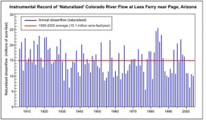
The amount of water that would naturally flow in the Colorado River has been estimated since 1906 at Lees Ferry, a historical landmark located approximately 12 miles south of Glen Canyon Dam and the town of Page, Arizona. This record demonstrates large year-to-year variability and captures the drought in the 1950s and the on-going drought (Figure 1). However, even 100 years of data is insufficient to observe the breadth of natural variability.
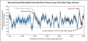
An extended record dating back to 762 AD that was pieced together from tree-rings reveals valuable information: streamflows in the Colorado River have been even more variable than those recorded since 1906; there have been longer, more severe droughts than those observed; and the current allocation of water exceeds the 100-year historical average(Figure 2).
In addition, a recent tree-ring study suggests that streamflows in the upper Rio Grande mimic those in the Colorado River at Lee’s Ferry. This suggests that large-scale climate changes impact both river basins in similar ways.
Observations and tree-ring analysis demonstrate that rivers naturally experience streamflow fluctuations and that modern southwestern populations have not experienced the brunt of this variability. Many scientists also believe that global warming will not only amplify the natural variability, but will also reduce snowfall, which is critical for southwestern streamflows. Rivers such as the Colorado that are over-allocated and dominantly supplied by snowmelt are especially vulnerable to future climate change.
Streamflow-related observations
Increases in temperature and alterations in precipitation patterns are driving the following observed changes in Southwest streamflows:
- The major pulse of spring snowmelt is currently occurring earlier than it did during the mid-20th century.
- In many rivers, the date when 50 percent of the average annual streamflow passes a measurement station has advanced by 10 to 30 days over the observational period of 1948 to 2000—the center of water mass is currently occurring earlier than the mid-20th century.
- A greater fraction of winter precipitation now falls as rain rather than snow. For example, the fraction of annual precipitation falling as rain rather than snow increased at three quarters of the weather stations located in the western mountain ranges between 1949 and 2004.
Streamflow-related projections
- Models generally project substantial declines in the average annual runoff in the Southwest due to higher evaporation, particularly in the summer months.
- Climate models suggest that average temperatures will continue to rise, causing many Southwest rivers to experience earlier peak streamflows.
- Models suggest that winter and early spring flows will increase, which will elevate the risk of flooding.
- As a result of higher temperatures, evapotranspiration by vegetation and evaporation in streams, lakes, and reservoirs will increase.
- Although precipitation predictions are less certain, models suggest that even moderate increases in precipitation will not offset the negative impacts to the water supply caused by temperature increases—some models project declines in Arizona streamflows between 20 and 40 percent, while New Mexico streamflows may experience reductions between 10 and 20 percent.
Climate change impacts on streamflows
- Declines in the amount of snow will reduce annual streamflows.
- Increases in the frequency and extent of droughts will also reduce streamflows.
- Higher temperatures will increase evaporative losses in reservoirs and streamflows.
- Higher temperatures and longer growing seasons (as a result of higher temperatures) will increase water consumption for domestic use, irrigation, and energy production.
- Periodic increases in winter and early spring streamflows as well as higher frequency of intense storms will produce more extreme floods.
- Earlier streamflows will cause reservoirs to fill earlier in the year. Consequently, reservoirs will be drained to avoid floods, wasting limited water that normally helps satisfy human demand.
- An advance in the timing of snowmelt will increase the length of the summer dry season, altering water and wildfire management and ecosystem interactions.
References
-
Christensen C. S., et al. 2004. The effects of climate change on the hydrology and water resources of the Colorado River basin. Climate Change, 62:337-363.
-
U.S. Bureau of Reclamation. 2008. Colorado River Basin Natural Flow and Salt Data Current Natural Flow and Salt Data.
-
http://www.usbr.gov/lc/region/g4000/NaturalFlow/current.html (Last accessed on August 11, 2008).
-
Meko, D. M., et al. 2007. Medieval drought in the upper Colorado River Basin. Geophysical Research Letters, 34: L10705, doi:10.1029/2007GL029988.
-
Personal communication with Connie Woodhouse, powerpoint presentation for Border-Area climate Change Impacts and Water Sector Adaptation Workshop, April 1-2, 2008
-
Knowles, N., M. D. Dettinger and D. R. Cayan. 2006. Trends in snowfall versus rainfall in the western United States. Journal of Climate, 19:4545-4559.
-
Field, C.B., et al. 2007. In: North America. In Climate Change 2007: Impacts, Adaptation and Vulnerability. Contribution of Working Group II to the Fourth Assessment Report of the Intergovernmental Panel on Climate Change. [Parry, M.L., O.F. Canziani, J.P. Palutikof, P.J. van der Linden and C.E. Hanson (eds).] Cambridge University Press, Cambridge, United Kingdom and New York, NY, USA.
-
Stewart, I.T., D. R. Cayan, and M. D. Dettinger. 2005. Changes toward earlier streamflow timing across western North America. Journal of Climate, 18:1136-1155.
-
Stewart, I. T., D. R. Cayan, and M. D. Dettinger. 2004. Changes in snowmelt runoff timing in western North America under a “business as usual” climate change scenario. Climatic Change, 62:217–232.
-
Adger, N., et al. 2007. Summary for policy makers, In Climate Change 2007: Contribution of Working Group II to the Fourth Assessment Report of the Intergovernmental Panel on Climate Change, [Parry, M.L., O.F. Canziani, J.P. Palutikof, P.J. van der Linden and C.E. Hanson (eds.)] pp.7-22. Cambridge University Press, Cambridge, UK and New York City, NY, USA.
-
Backlund, P., et al. 2008. The effects of climate change on agriculture, land resources, water resources, and biodiversity: Introduction. A Report by the U.S. Climate Change Science Program and the Subcommittee on Global Change Research. Washington, DC., USA, pp. 362
-
Milly, P.C.D, et al. 2008. Stationary is dead: Whither water management. Science, 318:573–574.
Images and Figures
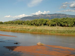
Image 1. The Rio Grande with the Sandia Mountains in the background, near Albuquerque, New Mexico. Photo taken in September.
Credit: ©Jill Fromer, istockphoto.com
Figure 1. Instrumental record of Colorado River streamflows. The naturalized flow of the Colorado River has varied between 5.3 and 24.0 million acre-feet per year at Lees Ferry near Page, Arizona. Naturalized flow is an estimate of the River's flow that would occur in absence of human diversions or withdrawals. One acre-foot is equal to approximately 326,000 gallons.
| Enlarge This Figure |
Credit: Zack Guido, CLIMAS, The University of Arizona
Figure 2. Time series plot of past Colorado River flows.
| Enlarge This Figure |
Credit: Dave Meko, Laboratory of Tree-Ring Research, The University of Arizona