Southwest Climate Outlook November 2015 - Climate Summary
Originally published as part of the Nov 2015 CLIMAS Southwest Climate Outlook
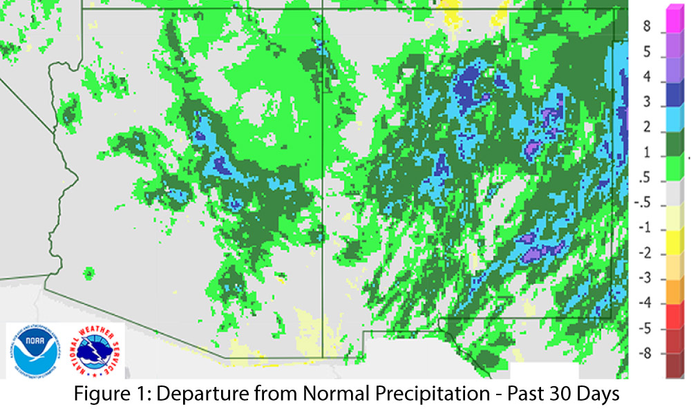
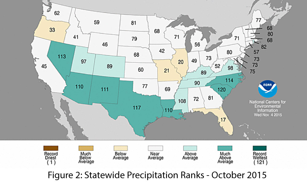
Precipitation: Over the past 30 days, much of Arizona and most of New Mexico recorded above-average precipitation (Fig. 1), as a number of storm systems brought moisture into the region. October rainfall was well above average across most of the southwestern U.S., with top 10 precipitation totals in Texas, New Mexico, and Nevada, and top 15 precipitation totals in Arizona (Fig. 2). November rainfall has been varied, with a mix of above and below-average precipitation.
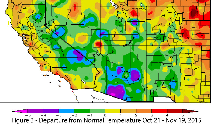
Temperature: November has been cooler than average, particularly in Arizona and most of New Mexico (Fig. 3). These temperatures represent a stark change from October, which was warmer than average in both states. 2015 is set to rival 2014 as the warmest year on record, and we will watch to see whether early November reflects a short-term swing back towards ‘normal’ cooler winter temperatures, or whether the rest of 2015 will warm back up to make a run at the record.
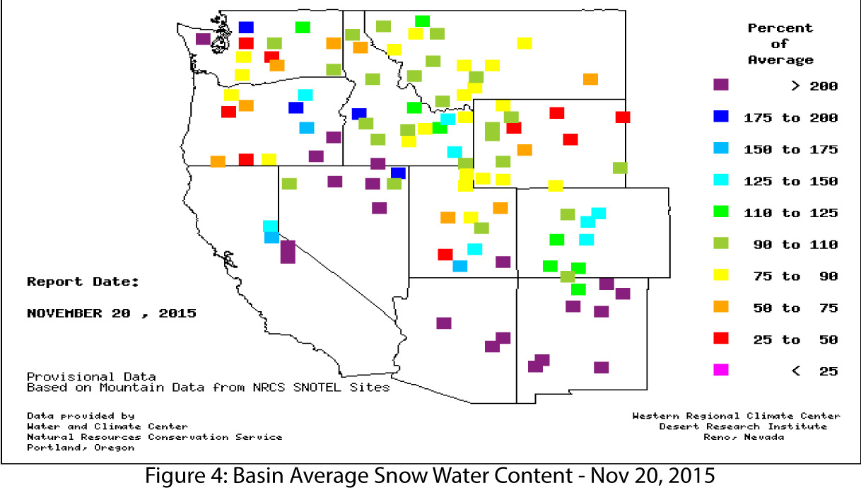
Snowpack & Water Supply: Early season snowfall has resulted in some impressive values on snow water equivalent (SWE) percent of average maps (Fig. 4) but also highlights the variability of early season snow coverage across the West. It remains to be seen whether forecasted increases to winter storm activity will occur in the Southwest, and the role that temperature will play in terms of how precipitation will fall (snow vs. rain) and how long snowfall will last before being lost to runoff or sublimation.
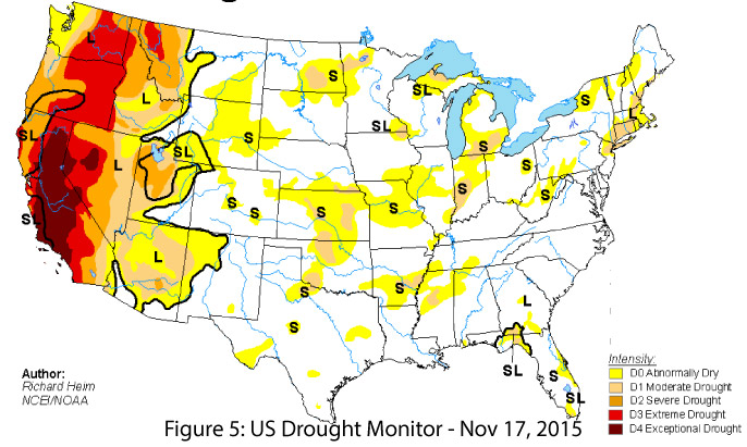
Drought: Drought conditions remain across much of Arizona and small portions of eastern New Mexico (Fig. 5), but the above-average precipitation this fall and a near-average 2015 water year have helped scale back the intensity of drought characterizations across Arizona and New Mexico. If the current El Niño event brings above-average winter precipitation to the Southwest, it will further help temper the effects of years of drought.
Tropical Storm Activity: In the second half of October, two major hurricanes, Olaf and Patricia, formed in the eastern Pacific Ocean; Patricia escalated to a category 5 storm and made landfall in Mexico. As of Nov. 20, Rick is off the Pacific coast, and earlier models showed it had potential to push into the Southwest. The eastern Pacific tropical storm season has been very active, and the National Hurricane Center reported that accumulated cyclone energy (ACE) through the end of October was approximately 50 percent higher than the 1981–2010 median value. An above-average eastern Pacific tropical storm season was forecasted this year, with the strong El Niño event being a major component of that forecast.
Precipitation & Temperature Forecasts: The Nov. 19 NOAA-Climate Prediction Center seasonal outlook predicts above-average precipitation for most of the Southwest this fall into winter, with progressively increasing chances of above-average precipitation to the south (Fig. 6, top). Temperature forecasts are split, with elevated chances for above-average temperatures along the West Coast and extending to the western edge of Arizona, and increased chances for below-average temperatures centered over Texas and extending across most of southeastern New Mexico (Fig. 6, bottom).
