Southwest Climate Outlook February 2019 - Climate Summary
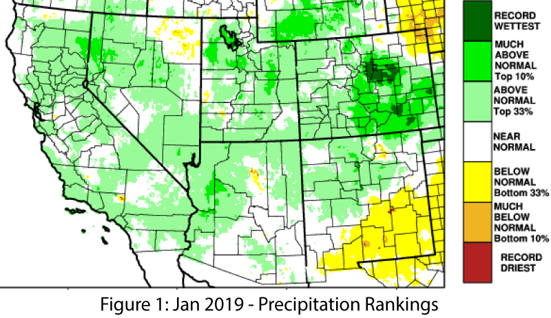
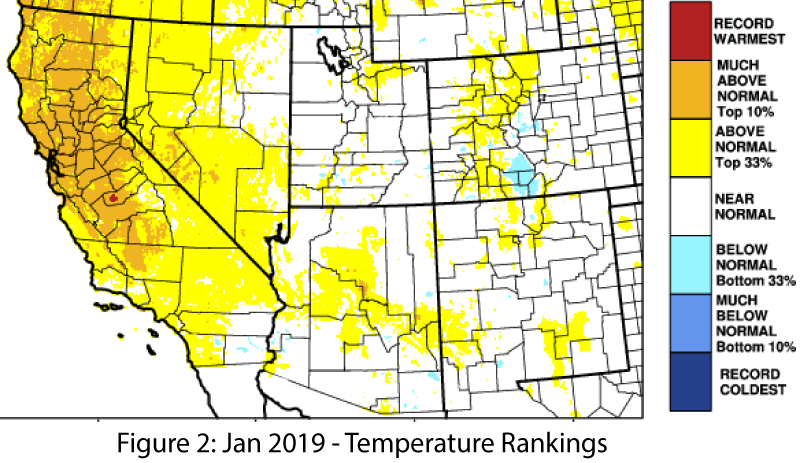
January Precipitation and Temperature: January was wetter-than-normal across much of northern Arizona and New Mexico, near-normal in southern Arizona, and below-normal across most of southern New Mexico (Fig. 1). January temperatures were normal to above-normal (Fig. 2). Winter storms brought wet and cool conditions to the region in February – including some heavy snow forecast later in the week of Feb 18. These storms feel like a departure, but may simply be closer to normal winter conditions in the Southwest, with expectations having shifted after persistent warm and dry winter conditions over the past few years or decades.
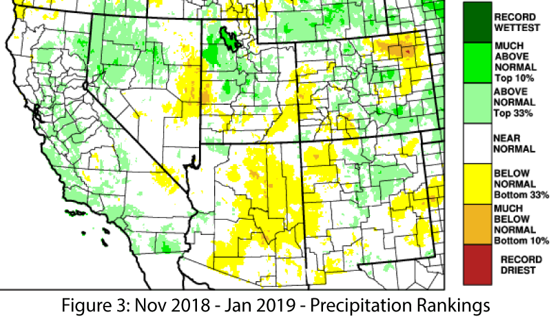
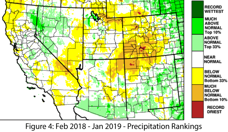
Seasonal & Annual Precipitation and Temperature: Nov-Jan precipitation was mostly normal to below-normal across Arizona and most of New Mexico (Fig. 3), while the temperature rankings were normal to above-normal in Arizona, and below-normal to above-normal in New Mexico. Water year precipitation includes a particularly wet October, and most of the Southwest recorded above-normal precipitation since Oct. 1, while 12-month totals highlight above-normal precipitation in southern Arizona and New Mexico, and persistent precipitation deficits in the four corners region (Fig. 4).
Drought: The Feb. 14 U.S. Drought Monitor (USDM) shows modest but widespread improvements in regional drought conditions, with much of Arizona and the four corners region seeing up to two levels of improvement in their drought designation (Fig. 5). Persistent drought conditions remain in the Four Corners region, although characterizations of drought extent and intensity are reduced on this map. Accumulated precipitation de cits built up over seasons and years, and weekly snapshots may struggle to capture the nuance of drought conditions that work across multiple timescales. This also applies to drought recovery, where above-normal precipitation in the short term is likely insuficient to make up for years of drought, but above-normal cool season precipitation should help in both short and long-term timescales.
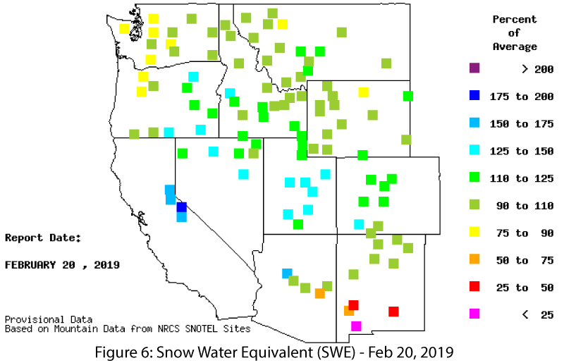
Snowpack & Water Supply: Snow water equivalent (SWE) increased since last month. SWE values (as of Feb. 20) in northern Arizona and New Mexico are near normal, ranging from 90-110 percent of average, while southern stations are lower, ranging from less than 25-percent to 75-percent of average (Fig. 6). Heavy snowfall forecast for Feb 21-22 would increase these values considerably, but it remains to be seen how widespread this event will be in the Southwest. Reservoir storage remains a persistent concern, as water levels have been impacted by long-term drought and accumulated precipitation deficit. Most of the reservoirs are at or below their long-term averages, and a few of the
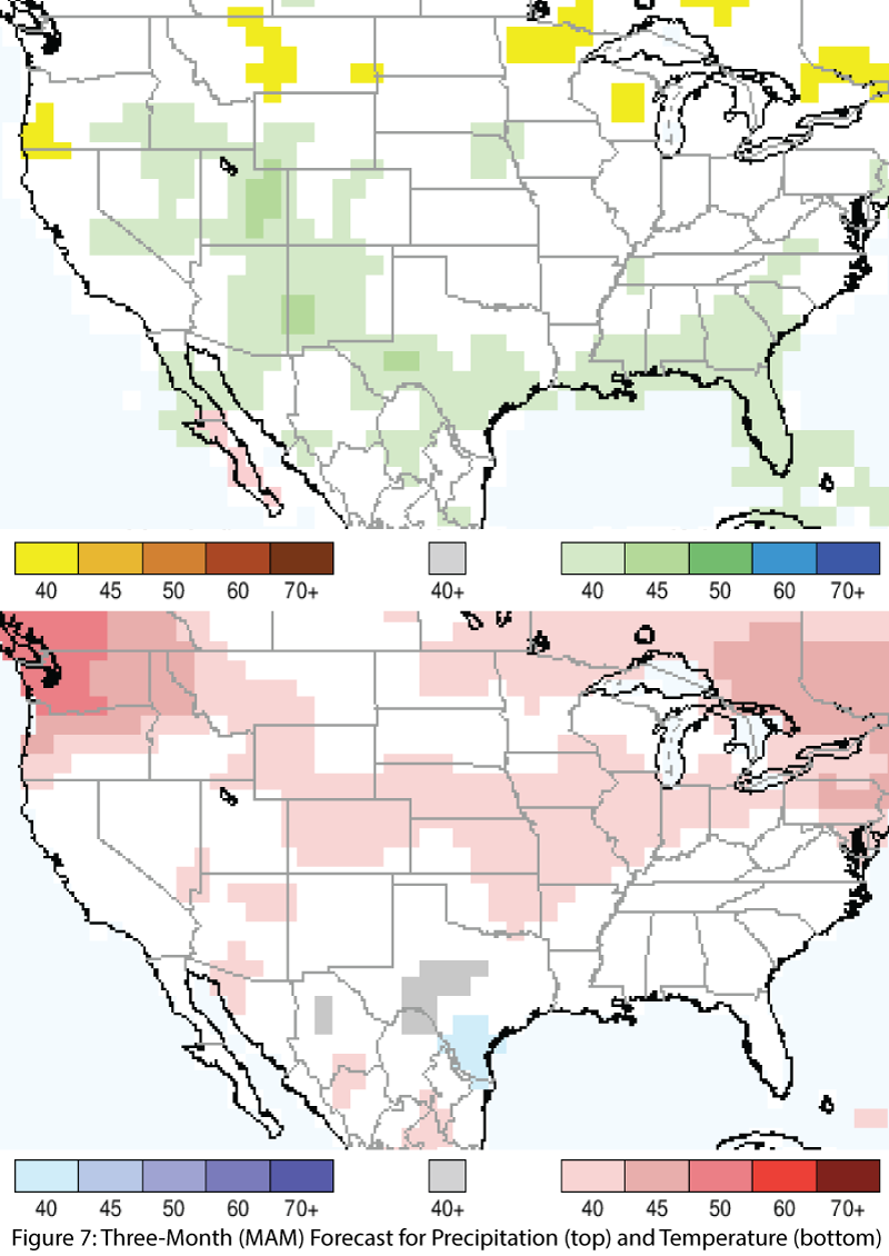
El Niño Tracker: In the on-again, off-again saga, we are back “on” for a weak El Niño in 2018-2019, with a possible second year of El Niño in 2019-2020 (reminiscent of the sequence in 2014-2015 and 2015-2016). The atmospheric conditions are nally catching up with the ocean, and while the equatorial waters had cooled, they remain borderline weak El Niño, and a pulse of warm sub-surface water is poised to help. What this means for the Southwest, especially in the cool season that remains, is up in the air (see El Niño Tracker on p. 3 for details). Given a choice, and considering the accumulated drought conditions over the past months and years, anything that hints at wetter and cooler than average conditions – or even to simply have a ‘normal’ southwestern winter – is welcome. Precipitation and Temperature Forecast: The three-month outlook for March through May calls for increased chances of above-normal precipitation in most of Arizona, New Mexico, west Texas, and northern Sonora (Fig. 7, top). The three- month temperature outlook calls for slightly increased chances of above-normal temperatures in pockets of Arizona and Sonora, but otherwise would suggest equal chances of above, below, and near normal temperatures (Fig. 7, bottom).
Online Resources
- Figures 1-4,6 - Western Regional Climate Center - wrcc.dri.edu
- Figure 5 - U.S. Drought Monitor - droughtmonitor.unl.edu
- Figure 7 - International Research Institute for Climate and Society - iri.columbia.edu


