Southwest Climate Outlook December 2015
Precipitation: Over the past 30 days, Arizona recorded mostly below-average precipitation, while most of New Mexico received normal to above-average precipitation (Fig. 1). This short term variability is typical in the seasonal transition, but looking more generally over the last three months we see a consistent pattern, and one with the fingerprints of El Niño all over it (primarily via enhanced tropical storm activity): both Arizona and New Mexico recorded top 20 precipitation totals for September through November (Fig. 2).
 Image Source - Advanced Hydrologic Prediction Service
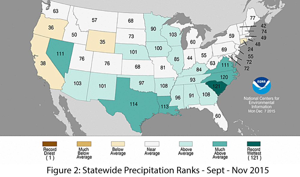 Image Source - NOAA - National Centers for Environmental Information
Temperature: November was cooler than average in most of Arizona but average to above-average across most of New Mexico (Fig. 3), a pattern which has persisted over the past 30 days. This cool down is relatively recent; the last three months (September through November) were record warm for New Mexico and near-record warm for Arizona. Year-to-date (January through November) temperatures are among the top five warmest for both Arizona and New Mexico.
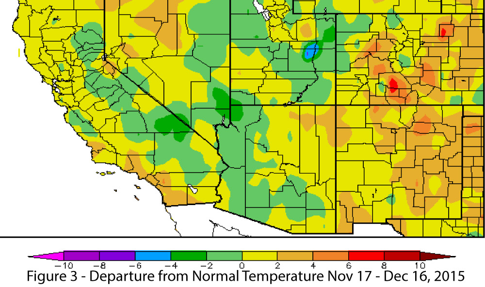 Image Source - High Plains Regional Climate Center
Snowpack & Water Supply: We are early in the snow season, and while some early storms brought impressive snow totals to portions of the west for this time of year, snow water equivalent (SWE) percent of average reflects the variability we might expect at this point in the season (Fig. 4). We will have a much better picture of El Niño’s contribution to winter precipitation looking back later this spring than we do looking forward, and we will have a better sense of how temperature affected patterns of rain and snow and the contributions to water supply (See reservoir totals).
 Image Source - Western Regional Climate Center
Drought: Long-term drought conditions persist across nearly all of Arizona and portions of northwestern New Mexico (Fig. 5). Average to above-average 2015 precipitation has helped mitigate some of the short-term drought conditions, but multi-year droughts, which we have experienced for much of the 21st century, will require multi-year periods to fully recover. The ongoing El Niño event offers hope for additional drought relief. Above-average precipitation over the winter helps saturate soils and build snowpack in the region, which could lead to higher reservoir storage during springtime snowmelt runoff events.
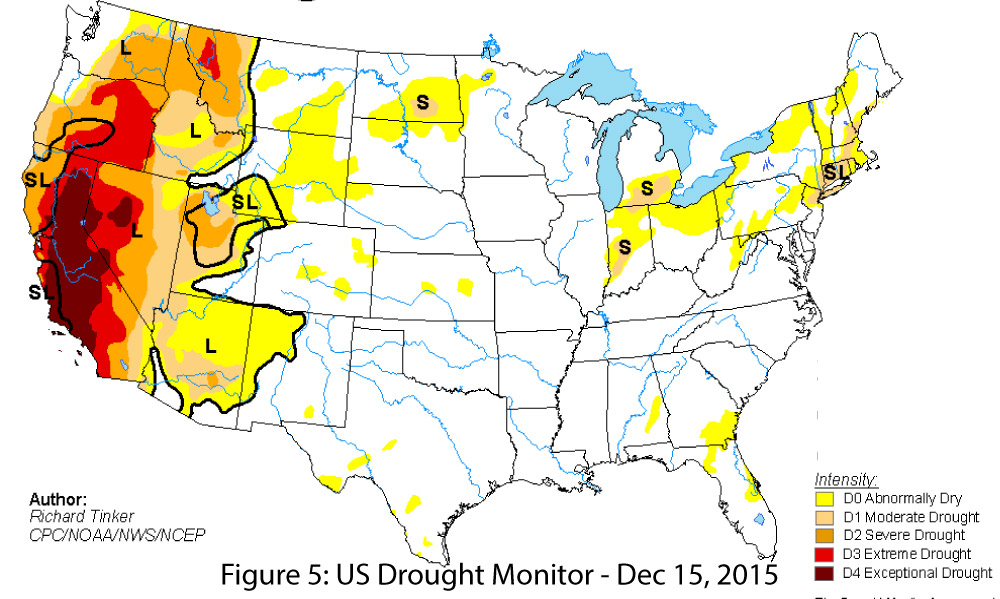 Image Source - U.S. Drought Monitori
Tropical Storm Activity: In a normal year, we would have nothing to say about tropical storms in mid-December, but a few late season storms, including major Hurricane Sandra, popped up in late November, long after the typical season. This capped an eastern Pacific tropical storm season that shattered existing records and almost certainly was associated with the current strong El Niño event (see recap of tropical storm season).
Precipitation & Temperature Forecast: The December 17 NOAA-Climate Prediction Center seasonal outlook predicts above-average precipitation for most of the Southwest this winter, with progressively increasing chances of above-average precipitation to the south (Fig. 6, top). Temperature forecasts are split, with elevated chances for above-average temperatures along the West Coast and increased chances for below-average temperatures centered over Texas and extending across most of southeastern New Mexico (Fig. 6, bottom).
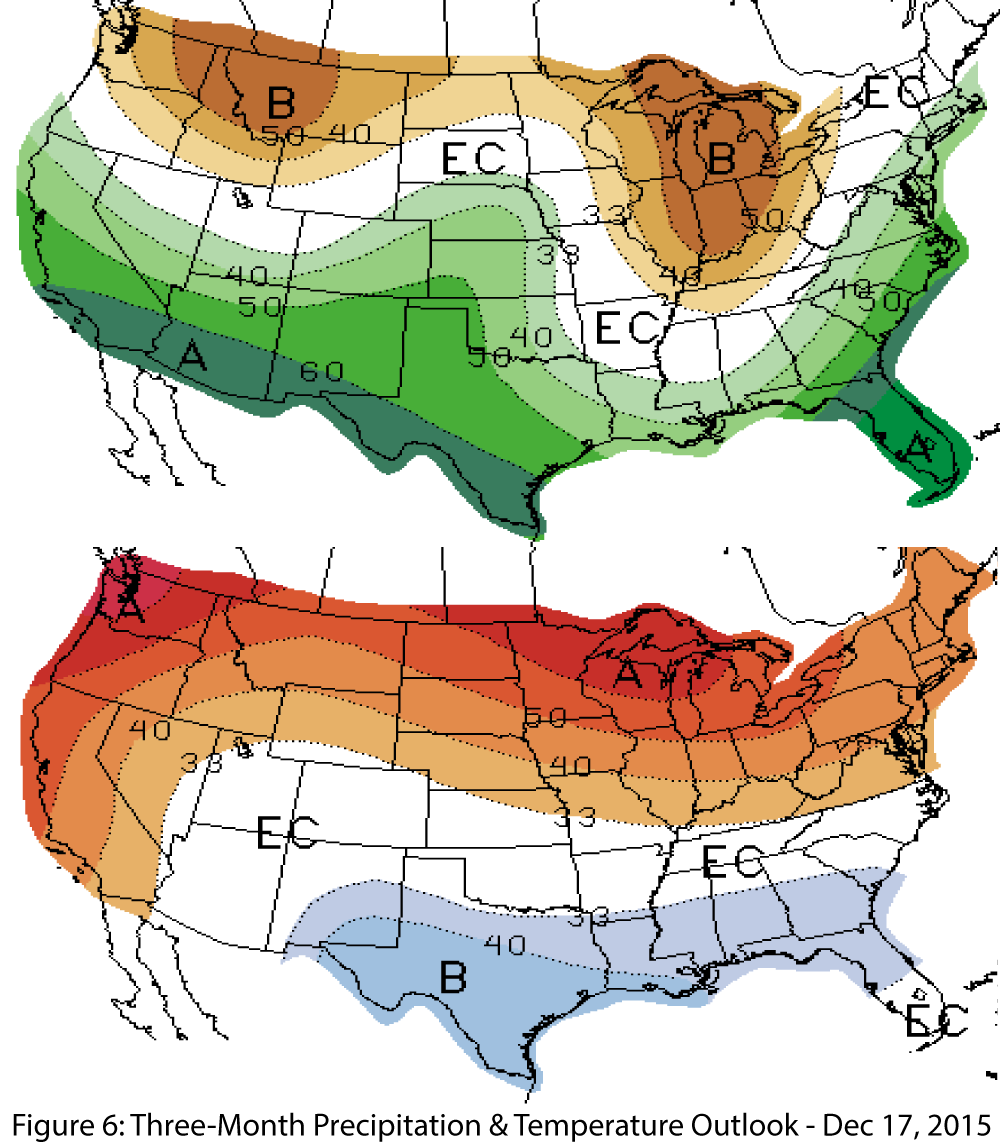 Image Source - NOAA/NWS - Climate Prediction Center
In this Issue: