El Niño Tracker - Southwest Climate Outlook February 2015
Originally published in the Feb 2015 CLIMAS Southwest Climate Outlook
2014-15 El Niño Tracker
A definitive 2014–2015 El Niño forecast remains elusive. Weak El Niño conditions have continued in 2015, but recent backsliding in SST anomalies (Fig. 1), especially in the Niño 1-2 regions (Fig. 2), along with the ongoing lack of coordination between atmospheric and oceanic conditions, give little confidence that the 2014–2015 event will be characterized as anything more than a weak El Niño.
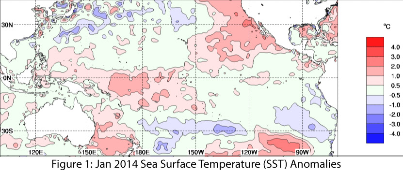
Image Source - Australian Bureau of Meteorology
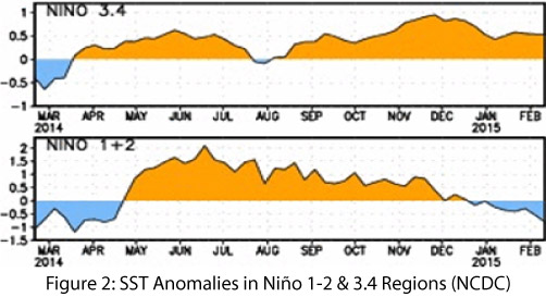
Image Source - NOAA-National Climatic Data Center
The most recent forecasts dialed back the probabilities for El Niño this winter and spring, and hinted we could swing to ENSO-neutral by late spring. On Feb. 5, the NOAA-Climate Prediction Center (CPC) issued another El Niño Watch, maintaining a 50–60 percent probability of an El Niño event, most likely a weak event extending into late winter or early spring. On Feb. 10, the Japan Meteorological Agency continued its assessment that El Niño conditions had been present in the equatorial Pacific for multiple months. They noted uncertainty as to the length or intensity of an El Niño event, with emphasis on a weak event that would transition to ENSO-neutral by early spring. On Feb. 17, the Australian Bureau of Meteorology kept its El Niño tracker status at neutral, given the fade in SST anomalies and lack of clear atmospheric signal. On Feb. 19, the International Research Institute for Climate and Society (IRI) and CPC reasserted a 50–60 percent probability of an El Niño event (Fig. 3). Given the declining SST anomalies and lack of clear atmospheric signal, they characterized this event as a “borderline El Niño” that would last through early spring 2015. The North American multi-model ensemble shows a weak event that extends into summer (Fig. 4). This graph highlights the possibility of a continuation of a stronger El Niño signal into 2015 (a possibility that was discussed in the IRI-CPC forecast event), depending on how ocean and atmospheric conditions progress from summer into fall. The dynamical models currently favor a resurgence of El Niño conditions, while the statistical models suggest an ENSO-neutral state.
As with last month, we remain in “El Limbo” with seasonal forecasts still indicating an increased chance of above-average precipitation across the Southwest for winter and early spring. These forecasts are linked to the projected influence of El Niño conditions, but impacts associated with weak El Niño events are less certain than those associated with moderate or strong events (past weak events have brought both dry and wet conditions to the Southwest during the winter). A number of storm events have moved through the Southwest in late 2014 and early 2015, but conditions have not converged to produce widespread above-average precipitation over an extended period of time. For this El Niño event to be of some utility in mitigating longer-term drought conditions, we would hope to see this convergence this winter into spring, with more widespread and sustained precipitation events.
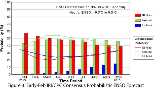
Image Source - International Research Institute for Climate and Society
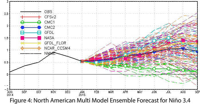
Image Source - NOAA-Climate Prediction Center