El Niño Tracker - March 2015
Originally published Mar 19, 2015 in the CLIMAS Southwest Climate Outlook
After months of vacillating sea surface temperature (SST) anomalies, limited coordination between oceanic and atmospheric conditions favorable to El Niño formation, and ongoing confusion regarding the strength of the various diagnostic signals, El Niño has “officially” arrived in North America. This is late in the season to declare an El Niño, and the so-called spring predictability barrier makes it difficult to anticipate how seasonal changes, particularly westerly wind bursts, will help or hinder the ongoing conditions favorable to El Niño. This has been a strange season. Strong signals in early 2014 stalled in summer and into fall, delaying the event’s onset until this month, when ocean-atmosphere coupling and an additional Kelvin wave again indicated more favorable conditions for an El Niño event.
The most recent forecasts offer mixed signals regarding El Niño. On Mar. 5, the NOAA-Climate Prediction Center (CPC) issued an El Niño advisory, maintaining a 50–60 percent probability of a weak El Niño event developing and extending through the summer. On Mar. 10, the Japan Meteorological Agency declared the El Niño event likely to have ended, with greater likelihood of a return to El Niño than ENSO neutral conditions in the summer. On Mar. 17, the Australian Bureau of Meteorology elevated its El Niño tracker from neutral back to watch status, noting the “unusual conditions” in the tropical Pacific, including warmer-than-average SST anomalies (Fig. 1-2). On Mar. 19, the International Research Institute for Climate and Society (IRI) and CPC reasserted a 50–60 percent probability of this El Niño event extending into summer 2015 (Fig. 3), similarly noting atypical (or even strange) conditions that have made characterizing this particular event difficult. The North American multi-model ensemble shows a weak event extending into summer (Fig. 4), and corroborates the forecast discussion that suggests an increased possibility of a stronger El Niño signal extending into 2016. While the models are bullish on the possibility of a moderate to strong event, this will depend on how ocean and atmospheric conditions progress from summer into fall.
With a seemingly definitive El Niño declaration, we are finally out of “El Limbo”. While forecasting or characterizing this event has been difficult for all involved, the complexity of this El Niño will be of interest to climatologists for years to come. Looking forward, seasonal forecasts still indicate an increased chance of above-average precipitation through much of the Southwest for late winter and spring. Despite numerous storm events, we have yet to see widespread and sustained above-average winter precipitation in the Southwest, which would help considerably in mitigating longer-term drought conditions.
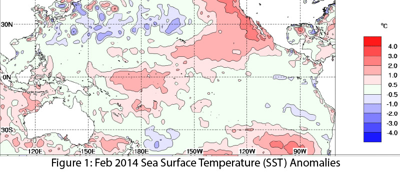
Image Source - Australian Bureau of Meteorology
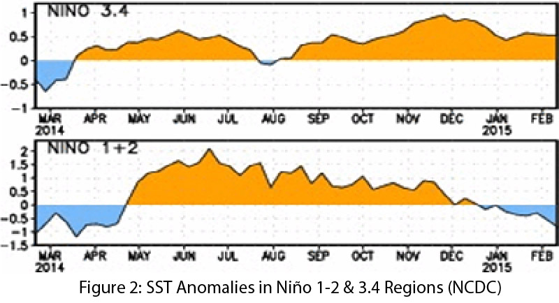
Image Source - NOAA-National Climatic Data Center
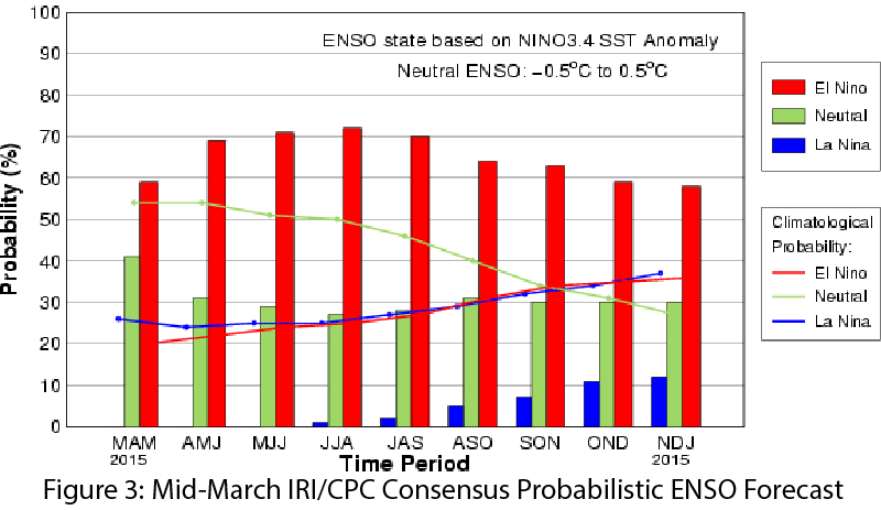
Image Source - International Research Institute for Climate and Society
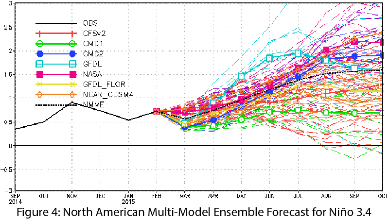
Image Source - NOAA-Climate Prediction Center