CLIMAS SW Climate Outlook - Wildfire Report: Sawmill Fire
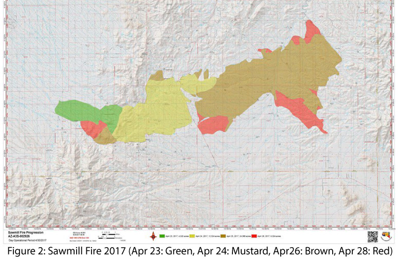
The Sawmill fire (Fig. 1) started, reportedly by recreational shooting, on April 23, 2017 in a grass- and shrub-covered area of low-elevation Arizona state lands approximately 40 miles south of Tucson. The fire spread quickly due to dry and windy conditions that day: the temperature reached 98 degrees, relative humidity ranged between 4 and 18 percent, and sustained winds reached 20 mph with gusts up to 30 mph. High winds, high temperatures, and low relative humidity continued through much of the following week, driving rapid growth of the fire (Fig. 2).
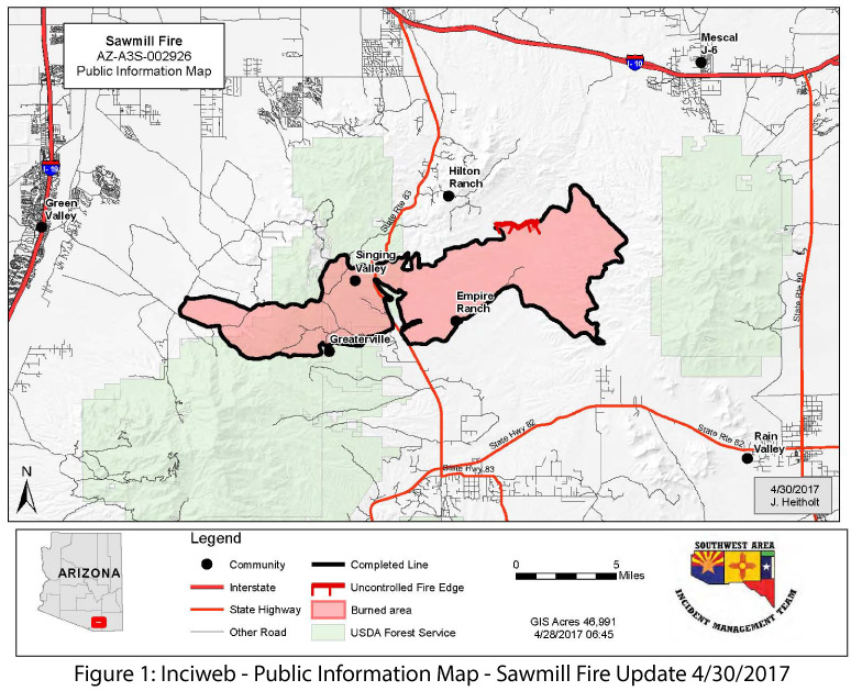
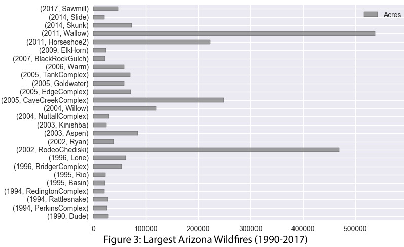
The strong winds whipped the fire along, challenging ground-level fire-line containment efforts and repeatedly grounding aerial support. Numerous communities and rural households were evacuated, and wildfire management was eventually escalated to a type 1 incident management team. At peak effort, nearly 800 firefighters and multiple aerial tankers were deployed to fight the fire, slow the spread, and protect communities and structures. Initial estimates of the fire put the total acreage burned at 46,991 acres, making it the 14th largest wildfire in Arizona history (Fig. 3).
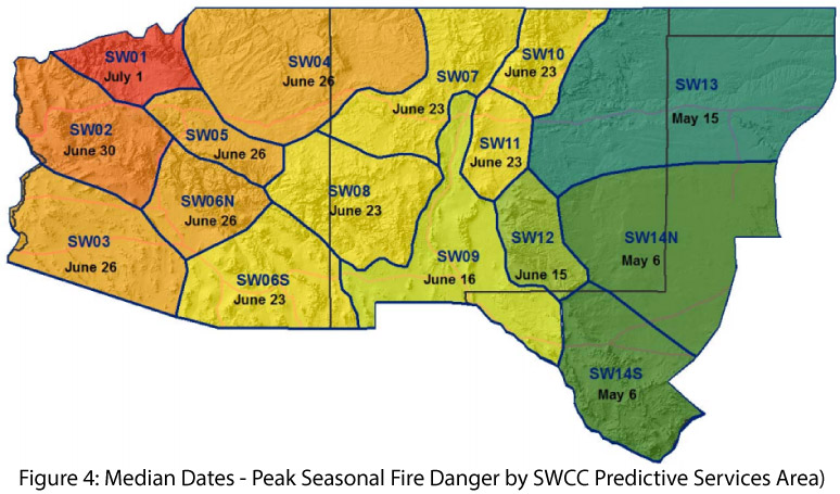
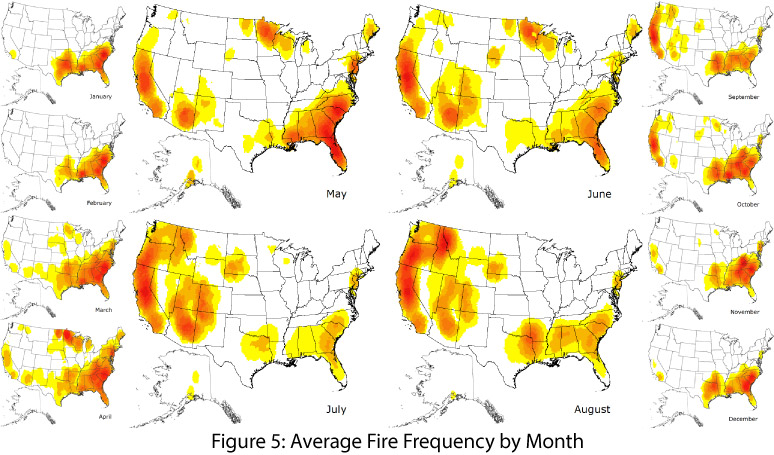
In the Southwest, peak seasonal wildfire danger varies across the region, ranging from early-mid-May to early June in eastern New Mexico, to late June in western Arizona (Fig. 4). This roughly corresponds to the progression of the monsoon, which brings some relief to the hot and dry conditions that characterize late spring and early-to-mid summer, although dry lightning associated with early monsoon storms sometimes serves as an ignition source for wildfire. June and early July are characterized by the warmest and driest conditions, reaching the peak of the warm-up and dry-out period of late spring into summer.
While fire is possible during most of the year, most wildfire activity clusters in this warm/dry summer period (Fig. 5). The Sawmill fire demonstrates that large fires are possible outside of the peak of summer wildfire season, and was likely the culmination of a set of circumstances that brought about enhanced wildfire risk earlier than is typical in Arizona.
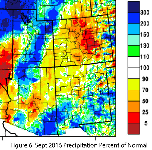
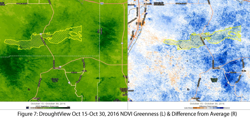
In September 2016, a surge in precipitation associated with hurricane Newton and lingering monsoon activity brought moisture into the Southwest, in particular to the southeastern corner of Arizona where the Sawmill fire broke out (Fig. 6). The rains boosted plant growth and green-up, and by mid-October, above-normal green-up was visible in satellite imagery of the grasslands in the region (Fig. 7).
Following this explosion of new vegetation, the region experienced an extended drier-than-average period, with water-year precipitation totals for the seven-month period of Oct 2016 to April 2017 well-below average in southern Arizona. (Fig. 8).

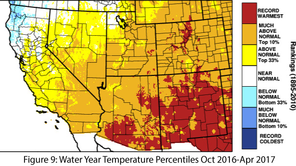
Temperatures during the same period were warmer than average across the Southwest, and in some locations approached or set records (Fig. 9). The relative wintertime warmth augmented by early January precipitation further enhanced plant growth. These moderate winter conditions extended the growing season and likely contributed to an early start for spring plant growth and development (for more details see the story about early arrival of spring conditions in 2017, links to a changing climate, and the National Phenology Network).
By late winter, however, heat and lack of precipitation (Fig. 10) had dried out the lower-elevation soils and the new vegetation began to dry out and die. By early-to-mid April, abundant fine fuels had accumulated. Add in strong winds and low relative humidity, and the stage was set for an earlier-than-normal significant wildfire event – all it needed was an ignition source. Although that source was a human, the fire itself, by virtue of its fast-moving nature, did not have severe adverse impacts to the soil and may ultimately be viewed as beneficial to the grasslands.
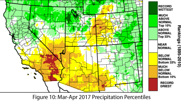
Image Credits
- Figure 1 - Inciweb - Incident Info. System
- Figure 2 - Sawmill Fire 2017
- Figure 3 - CLIMAS: Climate Assessment for the Southwest
- Figure 4 - Southwest Coordination Center
- Figure 5 - National Interagency Fire Center
- Figures 6,8 - WestWide Drought Tracker
- Figure 7 - UA Drought View - Climate Science Applications Program
- Figures 9-10 - High Plains Regional Climate Center