Is Better Understanding of Atmospheric Rivers a Key to Predicting Major Floods in the Southwest?
Residents of the Southwest know the consequences of flooding all too well. Every year during the monsoon season, Arizona and New Mexico experience numerous storms that result in flooding, ultimately causing millions of dollars in damage and sometimes, sadly, fatalities. One good thing about these storms, however, is that the majority of the time we are somewhat prepared, in that locals are generally aware that flooding is likely during monsoon season. But what about storms that cause flooding during the rest of the year?
For example, on January 19-21, 2010 a powerful winter storm brought 1 to 5 inches of rainfall to the Phoenix area, causing almost $4 million in damage. A state of emergency was declared in both Maricopa County and the entire state because of this “25- to 100-year event” (Flood Control District of Maricopa County). What if everyone had had 1-2 day warning of this storm, with adequate detail, before it occurred? Could the damages have been reduced?
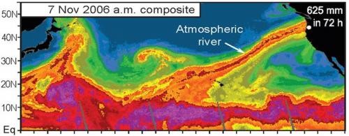
This is exactly what Marty Ralph, a researcher in the Physical Sciences Division at NOAA (and alumni of the UA Department of Meteorology), and others are currently trying to determine for the west coast of the U.S. Marty recently spoke at the University of Arizona, and explained that satellites, specifically the Special Sensor Microwave Imager (SSM/I), allow him and other scientists to observe and track what they call atmospheric rivers, or ARs for short. These “rivers”, so named because of their narrow width relative to their length, are slender corridors of water vapor transport in the lower atmosphere that can result in extreme precipitation and flooding when they strike land (Figure 1). ARs are attracting growing attention, partly because SSM/I, which measures vertically integrated water vapor (IWV) concentrations globally over the Earth’s oceans, became more widespread about 13 years ago, and NOAA’s Hydrometeorology Testbed-West (HMT-West) began looking into ARs in 2003 (Ralph and Dettinger, 2011).

The west coast of the U.S. frequently experiences these types of AR storms. When a strong AR (think very moist, with strong winds in the lowest 5000 feet of the atmosphere) stalls over an area for roughly a day or more, it can result in extreme rainfall and flooding (Figure 1). In fact, on the Russian River of central California, all storms that resulted in declared flood conditions from 1998 to 2006 were a result of ARs (Ralph et al., 2006). Not only can these storms create extreme flood events, but they also contribute significantly to water supplies along the west coast, especially in California where landfalling ARs typically contribute an average of one third to one half of yearly precipitation in only about 6-8 events (Ralph and Dettinger, 2011).
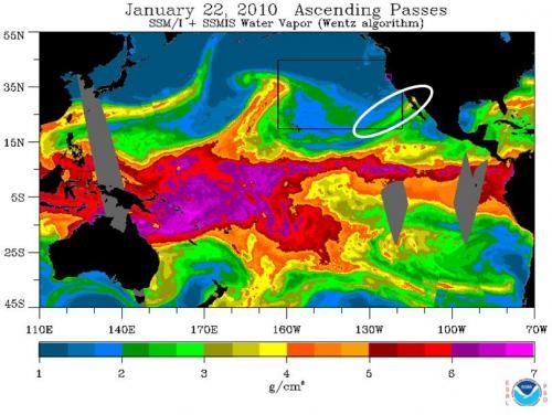
But what about the Southwest? Do ARs affect inland areas? The answer is quite possibly yes. Marty provided a few examples of extreme events that occurred during the AR season, from November to March, and thus may have been associated with ARs (keep in mind these results are preliminary and not published). For example, the Phoenix storm of January 2010 produced 34% of the total precipitation for that year over just 6 days (Jan. 18-24) at Workman Creek, a gauge site in a wet area above Roosevelt Lake northeast of Phoenix. When we look at SSM/I images, we see that in fact there was an AR that reached into this region during this time (Figure 2). Marty discussed two other such events, one in December 2010 that resulted in extreme precipitation in southern Colorado (as snow high in the San Juan Mountains) and southwestern Utah (as rain), and another in November/December 2007 with heavy rainfall in Tucson and snow in the San Juan’s of southern Colorado. During both of these time periods there was an AR striking the Southwest.

Now to the big question, are ARs a key to future forecasting of cool-season extreme precipitation and flooding in the Southwest? We know that they can create extreme precipitation and flooding along the west coast, and quite possibly the Southwest as well, but is it possible to anticipate their arrival? Multiple ongoing studies are attempting to answer this question. NOAA’s HMT-West uses monitoring and modeling to improve our understanding of ARs and develops and prototypes new tools to aid in short-term prediction of extreme precipitation associated with them. The Enhanced Flood Response and Emergency Preparedness program (EFREP) uses the findings from HMT-West, as well as the results from additional observatories and monitoring networks, to make these findings operational for possible detection of ARs. Meanwhile, the USGS’ Multi-Hazards project developed an emergency preparedness scenario for California to quantify impacts of a potential series of potent ARs (Porter et al. 2010). These are only a sample of several programs seeking to understand ARs and their potential detection and prediction (www.esrl.noaa.gov/psd/atmrivers/).
In the near future we may be able to better predict winter flooding events in the Southwest by applying the lessons learned about ARs, but unfortunately for now the current observations are not optimized for this purpose, and much remains to be learned about how ARs penetrate through the gauntlet of mountains between Arizona and their Pacific “spawning ground.”
(Thanks to Marty Ralph for his assistance and review)
References
Ralph, F. M., P. J. Neiman, G. A. Wick, S. I. Gutman, M. D. Dettinger, D. R. Cayan, and A. B. White, 2006: Flooding on California’s Russian River: Role of atmospheric rivers. Geophys. Res. Lett., 33, L13801, doi:10.1029/2006GL026689.
Porter, Keith, Wein, Anne, Alpers, Charles, Baez, Allan, Barnard, Patrick, Carter, James, Corsi, Alessandra, Costner, James, Cox, Dale, Das, Tapash, Dettinger, Michael, Done, James, Eadie, Charles, Eymann, Marcia, Ferris, Justin, Gunturi, Prasad, Hughes, Mimi, Jarrett, Robert, Johnson, Laurie, Dam Le-Griffin, Hanh, Mitchell, David, Morman, Suzette, Neiman, Paul, Olsen, Anna, Perry, Suzanne, Plumlee, Geoffrey, Ralph, Martin, Reynolds, David, Rose, Adam, Schaefer, Kathleen, Serakos, Julie, Siembieda, William, Stock, Jonathon, Strong, David, Sue Wing, Ian, Tang, Alex, Thomas, Pete, Topping, Ken, and Wills, Chris; Jones, Lucile, Chief Scientist, Cox, Dale, Project Manager, 2011: Overview of the ARkStorm scenario: U.S. Geological Survey Open-File Report 2010-1312, 183 p. and appendixes.
Ralph, F.M., and M.D. Dettinger, 2011: Storms, Floods and the Science of Atmospheric Rivers. EOS, Transactions, Amer. Geophys. Union., 92, 265-266.
Ralph, F. M., P. J. Neiman, G. N. Kiladis, K. Weickman, and D. W. Reynolds, 2011: A multi-scale observational case study of a Pacific atmospheric river exhibiting tropical-extratropical connections and a mesoscale frontal wave. Mon. Wea. Rev., 139, pp. 1169-1189, doi: 10.1175/2010MWR3596.1.

