2014/2015 El Niño Tracker: Oct 16, 2014
An El Niño Watch, issued by the NOAA Climate Prediction Center (CPC), continues for the seventh consecutive month as signs of an emerging El Niño are just on the horizon, but not quite here yet. Another slug of warm water (also known as a Kelvin wave), has been making its way across the Pacific Ocean from west to east just below the surface and is poised to emerge and help warm sea surface temperatures in the eastern Pacific over the next month or so. Westerly wind bursts, which help move this warmer-than-average water to the east, have occurred in the western and central Pacific but have been temporary and haven’t helped sustain a steady progression towards El Niño conditions, which typically peak during mid-winter.
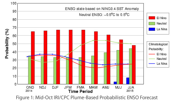
Forecast models are betting the current Kelvin wave and associated warm water in the east Pacific will finally get this fickle event to organize and roll forward as a weak El Niño; only a handful of models suggest a moderate-strength event. The early-October consensus forecast (Fig. 1) issued by the International Research Institute for Climate and Society (IRI) and the CPC still indicates more than a 65 percent chance of El Niño conditions developing during the November-December-January period and most likely persisting through early next spring. The impacts associated with weak El Niño events are much less certain than with stronger events, with similar past events bringing both dry and wet conditions to the Southwest U.S. during the winter. Seasonal precipitation forecasts still indicate an enhanced chance of above-average precipitation over the upcoming winter, but confidence in this forecast has wavered slightly because of the expected weak nature of the emerging El Niño.
This post was originally published as part of the October 2014 Southwest Climate Outlook