About - El Niño Southern Oscillation:
El Niño and La Niña are part of the El Niño-Southern Oscillation (ENSO), a natural fluctuation in oceanic sea surface temperatures (SSTs), surface air pressure, and winds between the east and west tropical Pacific Ocean. SSTs in the western Pacific are warmer than in the east, off the coast of South America –a gradient maintained by prevailing winds, called trade winds, that push warm equatorial waters west, allowing upwelling of cold sub-surface water to maintain cool SSTs in the east. During an El Niño event, the winds weaken or occasionally reverse, leading to warmer SSTs in the central and eastern Pacific, with unusually dry conditions in Indonesia and wet conditions in coastal Ecuador. During a La Niña event, these trade winds intensify, preventing warmer water in the west from moving east, and stacking warm surface water in the west. These events occur at intervals of 3-7 years. ENSO events in the tropics result in changes in broad-scale atmospheric circulation patterns, which can influence weather around the world.
The influence of ENSO on weather in the Southwest is tied to its tendency to change the position of the jet stream—the winds aloft that steer storm systems and dictate where areas of high and low pressure are positioned. During El Niño events, the jet stream over the Pacific Ocean becomes less wavy and splits into a strengthening subtropical jet stream north of the equator and a weaker polar jet stream, and can result in a greater number of storms and above-average precipitation across the Southwest during winter and early spring. La Niña events often bring drier-than-average winter conditions to the Southwest, as the jet stream curves and shifts north, diverting storms and precipitation away from the region (see figures below). El Niño does not guarantee a wet winter, just as La Niña does not consistently deliver dry conditions, but these are the patterns most associated with these events.
ENSO’s impact on summer weather is less clear, but El Niño events can delay the onset of the monsoon in Arizona and New Mexico by weakening and repositioning the subtropical high that guides moisture into the Southwest. El Niño events also influence development and strength of tropical storms in the eastern Pacific Ocean, and moisture associated with these storms has the potential to deliver above-average rain to the region, typically in late summer or early fall. While this welcome rain helps us to recharge reservoirs and aquifers, flooding can cause significant damage to infrastructure and extreme precipitation events have been associated with water-borne disease outbreaks and potential downstream changes to mosquito-borne diseases.
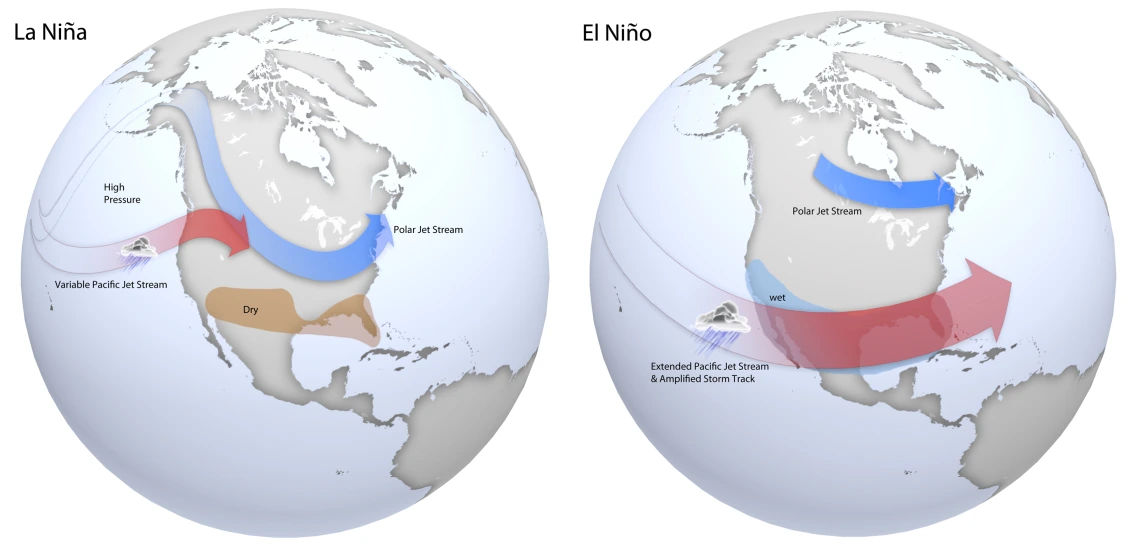
Typical late fall through early spring upper level jet stream positions associated with moderate to strong La Niña (left) and El Niño (right) events. During La Niña, a variable Pacific jet stream in association with a polar jet stream shifted further south favors below normal precipitation across the southern US, with below normal temperatures across the northern US. During El Niño, a strong and amplified Pacific jet stream extending across the southern US in association with a polar jet stream shifted further north into Canada favors above normal precipitation across the southern US, and above normal temperatures over the northern US. Based on original graphics from NOAA’s Climate Prediction Center
Links / Resources:
- Climate.gov: El Niño & La Niña (El Niño-Southern Oscillation)
- Climate.gov: ENSO Blog
- NOAA - NWS - Climate prediction Center: ENSO
- NOAA - NWS - CPC: El Niño/Southern Oscillation (ENSO) Diagnostic Discussion
- International Research Institute for Climate and Society, Columbia University Climate School: ENSO Resources
- Western Regional Climate Center: El Niño / Southern Oscillation (ENSO)